“The world is not an illusion,” said Alfred Korzbyski, “it is an abstraction.” You may know Korzbyski for another famous maxim, “the map is not the territory.” Jorge Luis Borges took this idea to its most absurd lengths by imagining in his story “On Exactitude in Science” a map that corresponded in size and scale at every point with the territory. Borges, wrote Colin Marshall in a previous Open Culture post, “illustrated the idea that all maps are wrong by imagining the preposterousness of a truly correct one.”
That observation occurs in the context of a video from Vox that explains why it is mathematically impossible to create a completely accurate flat world map at any scale.
We must abstract; “the surface of a sphere cannot be represented as a plane without some form of distortion,” and so cartographers use a technique called “projection.” The design mapmakers have most popularly used dates to 1569, from a cylindrical projection by Flemish cartographer Gerardus Mercator.
For either cultural or navigational reasons, this hugely distorted map inflates the size of Europe and North America and makes Greenland and Africa roughly the same size. A long overdue update, the Peters Projection from 1973, improved the Mercator’s accuracy, but at the cost of legibility and proportion.
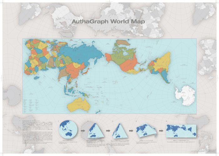
But last year, architect and artist Hajime Narukawa of Keio University’s Graduate School of Media and Governance in Tokyo solved these problems with his AuthaGraph World Map, at the top, which won Japan’s Good Design Grand Award, beating out “over 1000 entries in a variety of categories,” writes Mental Floss. You can view it in a larger format here.
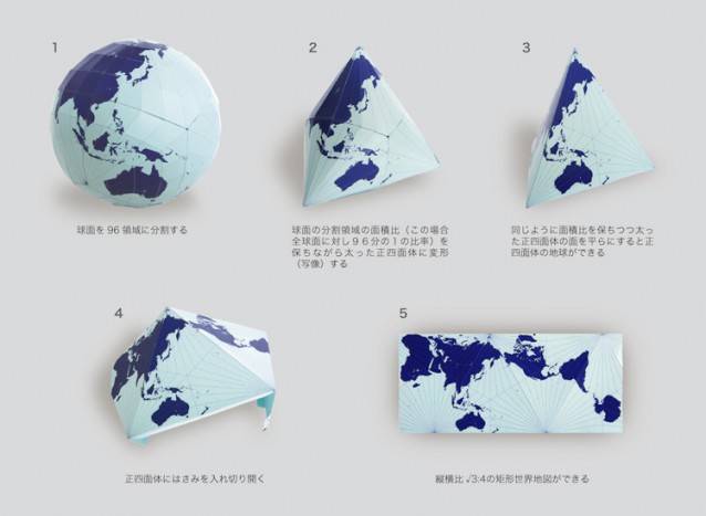
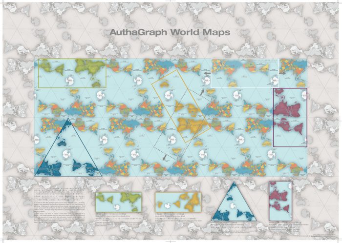
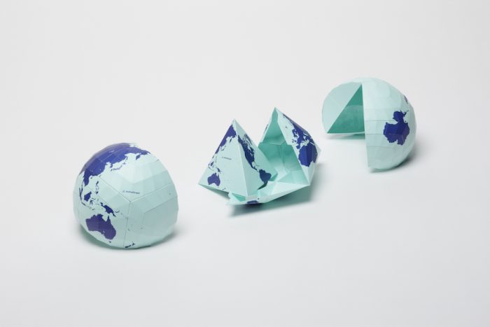
Instead of abstracting the globe into a cylinder, then a plane, as the Mercator Projection did, the AuthaGraph turns the earth into a tetrahedron, which then unfolds in any number of ways, as you can see further up, and “can be tessellated just like an MC Escher painting… much in the same way that we can traverse the planet without ever coming to an end.” Rather than one focal point—the North Atlantic in Mercator’s case—nearly any place around the earth can be at the center. Versions of the map are already being used in Japanese textbooks, and you can purchase a poster or buy a paper kit that allows you to unfold your own globe-to-tetrahedron-to-rectangle map (see above).
The video above from Ponder explains the AuthaGraph design, which is not—and could never be—100% mathematically accurate, but can, Narukawa writes, with “a further step” in its subdivisions “be officially called an equal-area map.” The concept was important to him because of the urgent relevance of globalist thinking. As he points out, writes Japanese design blog Spoon & Tamago, “A large bulk of the 20th century was dominated by an emphasis on East and West relations. But with issues like climate change, melting glaciers in Greenland and territorial sea claims, it’s time we establish a new view of the world.” Those in the centers of Eastern and Western power ignore the rest of the world at everyone’s peril. It may help to have a much more equitable way to visualize our shared planet.
Note: Several readers mentioned that this map seems obviously influenced by Buckminster Fuller’s Dymaxion map. We have since written a separate post on that. Find it here.
Related Content:
Why Making Accurate World Maps Is Mathematically Impossible
Browse & Download 1,198 Free High Resolution Maps of U.S. National Parks
Josh Jones is a writer and musician based in Durham, NC. Follow him at @jdmagness

“For either cultural or navigational reasons”
Please stop perpetuating the fiction that the Mercator projection is some sort of cartographic ethnocentrism. The Mercator projection is used because of its mathamatical simplicity and it’s navigational utility.
The persistence of this myth is the result of widespread innumeracy.
“it’s [sic] navigational utility.”
Try again.
Your error might be unconscious. Mercator’s ethnocentrism might also have been unconscious. Either way, you’re both wrong.
plagiarised from r. buckminster fuller…..shame…
Hi Joesixpack, I never used the word “ethnocentrism,” nor implied that Mercator had some consciously biased agenda. These are your projections onto my article.
The world’s most accurate map, produced by a Japanese man, just happens to have Japan right smack in the middle, right-side-up (as we usually know it), whereas almost every other country is splayed out to the side and (to our eyes and likely those countries’ inhabitants’ eyes) tilted. It is more accurate than many maps in various ways, but I can’t help but wonder if this “objective” projection would look quite the same if the designer were from Brazil or Mauritania.
@E
Read the article. this map can be centered on any point on the earth because it is an unfolded tetrahedron (a shape with flat faces).
he probably put japan in the centre because he is japanese and submitted the design for a contest in japan.
” Mercator’s ethnocentrism might also have been unconscious. Either way, you’re both wrong.”
Mercator was from Greenland right? I mean, that is the landmass which was exaggerated more than any other, so by your logic…
Do you understand Trigonometry as well as you understand the use of the apostrophe? Can you explain why maneuvering boards are Mercator projections? They don’t have any landmasses on them.
Do you know the difference between a loxodrome and a great circle?
I have no idea how ethnocentric Mercator was, but I can assure you that his choice of projection based on the simplest trig functions had nothing to do with his putative bias.
Sorry, perhaps I misread you. You suggested that there may have been a cultural reason behind Mercator’s projection. Do you also believe that there is a cultural reason behind making wheels round? Perhaps there are cultures out there who may have chosen a different shape?
Of course not. We all know that wheels have to be round for them to function as we expect a wheel to function.
The same is true of map projections. Mercator didn’t design his map for the front of classrooms to show the relative sizes of the continents, he designed it for the purpose of navigation, and for that purpose it is excellently suited. Compass directions are straight lines on a Mercator projection, on any other projection they will be a curve except for one single heading.
” Mercator’s ethnocentrism might also have been unconscious. Either way, you’re both wrong.”
Mercator was from Greenland right? I mean, that is the landmass which was exaggerated more than any other, so by your logic…
Do you understand Trigonometry as well as you understand the use of the apostrophe? Can you explain why maneuvering boards are Mercator projections? They don’t have any landmasses on them.
Do you know the difference between a loxodrome and a great circle?
I have no idea how ethnocentric Mercator was, but I can assure you that his choice of projection based on the simplest trig functions had nothing to do with his putative bias.
.…or pretty close to it. Fuller’s ” Dymaxion” map starts with projection onto an icosahedrons, but the concept is clearly the same.
Joesixpack: It has nothing to do with my beliefs. I was referring to the so-called “map wars.”
http://www.markmonmonier.com/rhumb_lines_and_map_wars__a_social_history_of_the_mercator_projection_39886.htm
You’ve obviously resolved the issue satisfactorily. I don’t have the requisite expertise and so defer to those who do.
“The design mapmakers have most popularly used dates to 1569, […]”
Not really, I think this is a myth. Even Mercator himself already knew and used equal-area projections.
Cylindrical equal-area projections have been around at least since Lambert 1772 and Behrmann 1910. Peters was just better at marketing his non-invention.
The National Geographic Society has not used Mercator for world maps for a very long time, but Van der Grinten, Robinson and Winkel Tripel, which are all compromise projections much better than Mercator (Van der Grinten not so much as the other two).
Good equal-area projections are around at least since Mollweide 1805 or Goode Homolosine 1923.
So neither Peters nor Authagraph were revolutionary or more accurate than anything known before.
“But last year, architect and artist Hajime Narukawa […] solved these problems with his AuthaGraph World Map, […]”
Not true. Authagraph has been around since 1999. It just won this design award last year.
Unfortunately, neither your article nor the Wikipedia article nor the AuthaGraph website are good at explaining how this projection *really* works.
How do I get back from a bunch of triangles to a rectangle without distortion or displacement?
In fact, the distances, for example between Antarctica and Australia, look heavily inaccurate.
Every map is a compromise. No one projection resolves “THE” problem of cartography, but every different projection solves ~A~ problem.
Why no mention of the Bucky Fuller dymaxion map? This is a slight modification of his design. Really glaring omission.
Hi Jessica,
We did a follow up post on Fuller’s map. You can find it here: http://www.openculture.com/2017/02/buckminster-fullers-map-of-the-world.html
Cheers,
Dan
Im just wondering: Is this an advertisment of some sort? Where is the open and free cultural media? it seems i can only buy posters. Strange!
Buckminster Fuller did this already but used the Icosahedron for greater accuracy in 1943. I like that the tetrahedron version can be tessellated on a sheet into a wallpaper style image.
‘that was’…smart arse’!
‘that was’…smart arse!
Thanks for the excellent link!
No, Mercator was from Belgium.
R. Buckminster Fuller’s Dymaxion Projection of Earth is the obvious precursor of the Authagraph map by 73 years. During that interval it has been constantly available to students, professional cartographers and the curious in print and, now, online. It seems inconceivable that Authagraph drafter were unaware Fuller’s original approach to depiction our world as one island in a world ocean and eliminating errors in landmasses. Any casual keyword search or query of any library would have returned Fuller’s brilliant solution as the first world map of the age of flight. To save face, the creators of Authagraph should quietly retract their drawing and acknowledge the primacy of Fuller’s first and unsurpassed accomplishment.
Navigation as a concept chances over time. In Mercator’s time European empires needed a reliable tool for going from home ports across the oceans — sometimes around the world — and back. The relative size of land masses was not important, sea routes were. This remained the case up to World War II and the ascendancy of the airplane. Fuller’s map is for the Air Age (and the collapse of European Empires) and puts the emphasis on getting the landmasses right because that’s where the plane take off from and land on. He ingeniously dispenses with the inevitable errors of going from sphere to 2‑D in the ocean margins. The coincidence of the dominance of the US Air Industry after WWII and Fuller’s approach to map technology might be a topic for another time. That’s my story and I’m sticking with it.
Thank you. I do enjoy maps so. For me, maps are the only place you can find and learn about our ture history. Because as we all know “history is dictated by the winners.”
As far as everyone that has negative comments on here, I must ask you this…
Why? You should encourage everyone to make maps. Never put down there interpretation of the world they live in. Again, thank you very much for this. Take care.
The designer of the map actually was aware of the Dymaxion map
“In an interview, Hajime Narukawa stated that he had Dymaxion as a guide on finishing his very own world map. This is why there are similarities that people can take note about the two. Though, the latest is surely the better one due to the fact that it even included Antarctica on accuracy.”
http://www.designtimes.com/articles/1887/20170227/buckminster-fuller-s-dymaxion-hajime-nakurawa-s-authagraph-the-battle-of-revolutionary-world-maps.htm
Hi,
the Ponder video does not contain any explanation of how the map is built. It’s just an ad.
And I expect better from Open Culture.
Thanks you,
Caroline
Hahahaha really??
Extention of south pole?
We dont live in an anime cone earth
What a trollogic