If we want to know the precise geographical location of, say, a particular church in Madrid, video arcade in Tokyo or coffee shop in Addis Ababa, we can figure it out in a matter of seconds. This is, in historical terms, a recent development indeed: many of us remember when the most detailed cartographical information we could get about distant lands (or for that matter, most of our own land) revealed to us only its cities and major roads — assuming we even had a world atlas at hand. Now, younger people take for granted the knowledge of not just where every place in the world is, but what it looks like, what its prices are, and what its visitors have said about it.
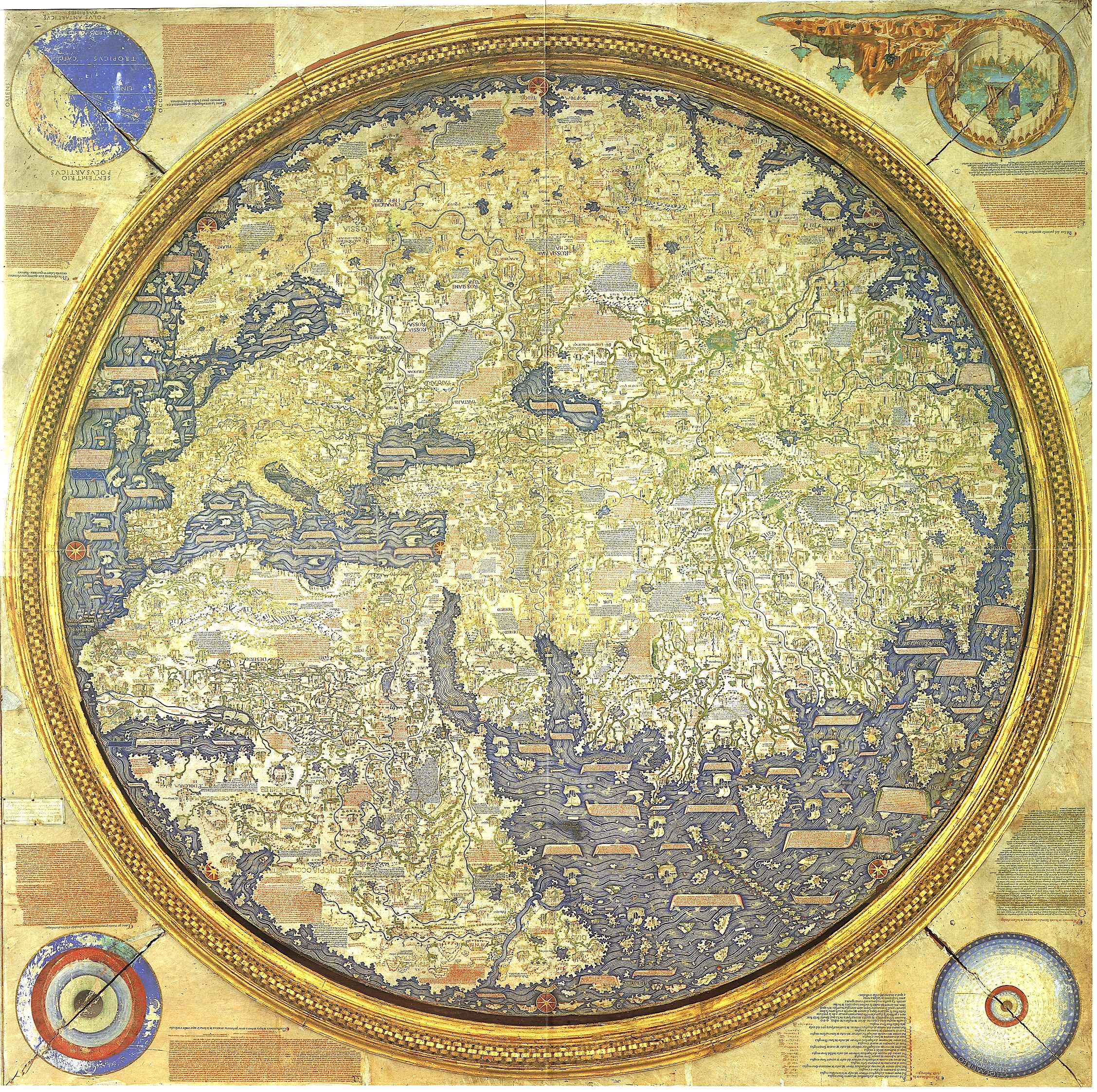
We live today, in other words, in the dream of Fra Mauro, the Venetian cartographer-monk of the late Middle Ages who created the most detailed and accurate world map to that point in human history. “As a young man, Fra Mauro had been a soldier and merchant of the famed Venice Merchant Fleet,” says the site of New World Cartographic. “His travels with the fleet around the Mediterranean and the Middle East resulted in his becoming interested in mapping, and he eventually settled in the monastery of San Michelle on the island of Murano, in the Venice Lagoon, where he became a lay brother.” In the early 1450s, “he was commissioned by King Afonso V of Portugal to create a map of the world.”
Portugal’s will to dominate world trade, which required the most detailed maps possible, was matched by Fra Mauro’s will to gather information about every corner of Earth, no matter how far-flung. And he could do that without leaving Venice: as Atlas Obscura’s Adam Kessler writes, “Arab traders and world explorers passed through the port, giving Fra Mauro an incomparable source of gossip and tall tales about the world. The fall of Constantinople, occurring a few years before the map was finished, would also have provided a rich source of well-traveled refugees, presumably willing to swap their stories for some bread or beer.” Not only did the map’s physical creation require a team of collaborators, the gathering of its contents relied upon the fifteenth-century equivalent of crowdsourcing.
This chapter of cartographical history invites such technological analogies: Kessler calls Fra Mauro’s completed mappa mundi “the Google Earth of the 1450s.” Despite his religious affiliation with the monastery of San Michele, Fra Mauro’s efforts produced an unprecedentedly radical rendition of the world. Breaking with religious tradition, he didn’t put Jerusalem in the center; “the Garden of Eden was relegated to a sidebox, not shown in a real geographic location.” His scrupulousness made him the first cartographer “to depict Japan as an island, and the first European to show that you could sail all the way around Africa.” While his map was “the most accurate ever made at the time,” its more than 3,000 annotations do contain plenty of tall tales, often of literal giants. But are they really much less trustworthy than the average twenty-first-century user review?
Related Content:
The World Map That Introduced Scientific Mapmaking to the Medieval Islamic World (1154 AD)
Explore the Hereford Mappa Mundi, the Largest Medieval Map Still in Existence (Circa 1300)
Europe’s Oldest Map: Discover the Saint-Bélec Slab (Circa 2150–1600 BCE)
Based in Seoul, Colin Marshall writes and broadcasts on cities, language, and culture. His projects include the Substack newsletter Books on Cities, the book The Stateless City: a Walk through 21st-Century Los Angeles and the video series The City in Cinema. Follow him on Twitter at @colinmarshall or on Facebook.
Why in the video would you say he had never stepped foot out of Venice but he traveled all over with the fleet?
Good
Because it’s two part explanation.
1st) His travels with the fleet around the Mediterranean and the Middle East resulted in his becoming interested in mapping. this was the 1st step in his development of becoming a map maker or cartographer.
2nd) Fra Mauro’s will to gather information about every corner of Earth, no matter how far-flung. And he could do that without leaving Venice. Fra knowledge was limited to Mediterranean and the Middle East. He never left Venice while he was creating the world map and was depending on both 1st and 2nd hand informational sources to create the map.
The Moroccan Sherif Idrissi had created the most accurate world map centuries before the monk. The monk created nothing. He just “borrowed” others’ hard work like many other European scientists of that time.
Sherif Idrissi’s map was the most accurate available *at his time.* Even the Arab world had more information available by Fra Mauro’s time, and Fra Mauro did exactly what Sherif Idrissi did — gather available information, and plot it onto parchment. His “creation,” like Idrissi’s, was in the writing-down.
Aziz,
I did professional cartography for a couple decades, early on using a GIS named, ironically, IDRISI (went to ArcGIS/ArcMap later). Idrisi’s maps are not better than Mauro’s, they’re different. Idrisi had less knowledge to draw from and fewer technical means at his disposal (he died in 1165 after all). Mauro’s map was made with more info available for many more regions, so has a lot more detail, so is naturally more accurate.
As Sandy says, “…Idrissi’s map was the most accurate available *at his time.*” He was on the cutting edge *in the 12th century*, and deserves great respect. Mauro was on the cutting edge in the 15th century and deserves equal respect.
re Idrissi etc
its worth noting that Idrissi was commissioned by Roger II of Sicily, along with other Arab and Islamic cartographers and geographers, to make the most authoritative map/atlas of the world at the time (circa 1138–1153) — calculating the circumference of the planet with an accuracy of within 10% (!) Along with many parchment maps, the complete map was apparently cut into a 7′ slab of silver, which is, unsurprisingly, lost. Wikipedia has details: Tabula Rogeriana.
I would suggest to people that before being critical of an article one might actually try reading it for its content, and absorbed what it actually says. Asking for clarification is one thing, but contradicting the author on a fact that they didn’t claim is just poor comprehension on the reader’s part. And since the poster who claims that collecting, organizing, sorting, ratifying, laying out, drawing and annotating the world’s largest Map “at the time” isn’t creating anything should never say that to the face of anyone in publishing, research, design, architecture, education, advertising or any of the other pursuits of human culture that add to our collected body of knowledge. He or she might get punched in the head by a highly-offended academic- thereby ‘creating’ a concussion. Happy now? Did you get your point across? “The monk created nothing” other than the impetus for an internet article over half a millennium after his death because of a life-crowning achievement of his intellect, artistic expression and true passion- passing on the truth of the world around him …and all of us! Nope, didn’t create a thing ..
I would suggest to people that before being critical of an article one might actually try reading it for its content, and absorbed what it actually says. Asking for clarification is one thing, but contradicting the author on a fact that they didn’t claim is just poor comprehension on the reader’s part. And since the poster who claims that collecting, organizing, sorting, ratifying, laying out, drawing and annotating the world’s largest Map “at the time” isn’t creating anything, I would recommend that they should never say that to the face of anyone who’s in publishing, research, design, architecture, education, advertising or any of the other intellectual pursuits of human culture that add to our collected body of knowledge. Such a feckless action by an obviously uninformed, inexperienced or dare I say ignorant individual could, quite conceivably, get one punched in the head by a highly-offended academic- thereby ‘creating’ a concussion. Happy now? Did you get your point across? “The monk created nothing” other than the impetus for an internet article over half a millennium after his death because of a life-crowning achievement using his intellect, artistic expression, communication skills and true passion- passing on the truth of the world around him …and all of us! Nope, didn’t create a thing ..
07- 08–02-03–014ort hidden mid drive pimph.
Either the map or your article is upside down.
Either the map or your article is upside down. Please fix!
العالم المسلم التدريس صاحب هذه الخريطة اللتى
سرقها مدعى العلم
The map isn’t upside down.
North didn’t become “UP” on a map really until the 16th century. So a lot of cartographers before then did their own orientations. Some parts of the world had the north=up concept well before the 16th century but it wasn’t really a universally accepted idea that everyone had to adhere to. In 1450, nobody would have cared which way the map was oriented as long as it worked.
Lol the image is most definitely upside down.… You can tell by looking at the illustrations in the corners lol A small.oversight as the scale of the image makes it not so easy to notice at a glance.
>The Moroccan Sherif Idrissi had created the most accurate world map centuries before the monk. The monk created nothing. He just “borrowed” others’ hard work like many other European scientists of that time.
Jesus Christ dude, have a couple beers and relax. Human civilization is built on its predecessors and its contemporaries. No one *truly* invents something from nothing. These maps are perfect examples — they both required the combined knowledge of thousands of people, perhaps even millions when you consider the resources and sailors required to explore the land and sea of Earth.
Sherif Idrissi and “the monk” were brothers of a sort, separated by time and space. Instead of getting frustrated and divisive, why not find joy in the combined contributions of Christians, Muslims, Buddhists, etc. to the advanced civilization we enjoy today. Science is the greatest collaboration of humanity.
Chinese maps of this same period typically had south as the “up” direction. Dwarvish maps of Middle-Earth use east.
Fra Mauaro’s work was significant enough to have a region of lunar highlands just south of Mare Imbrium named after him. It was the landing site of the Apollo 14 mission in 1971.
Call me whatever, but the map is exquisitely beautiful, & reading this article has given me goosebumps.
Thank you so much for this serendipitous education.
I am grateful.
~m