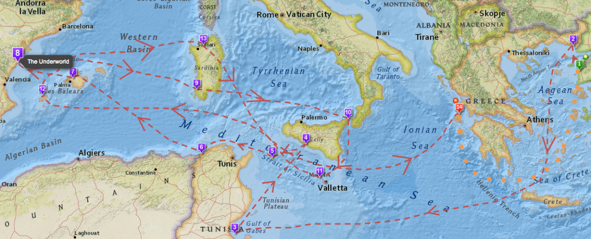
The Odyssey, one of Homer’s two great epics, narrates Odysseus’ long, strange trip home after the Trojan war. During their ten-year journey, Odysseus and his men had to overcome divine and natural forces, from battering storms and winds to difficult encounters with the Cyclops Polyphemus, the cannibalistic Laestrygones, the witch-goddess Circe and the rest. And they took a most circuitous route, bouncing all over the Mediterranean, moving first down to Crete and Tunisia. Next over to Sicily, then off toward Spain, and back to Greece again.
If you’re looking for an easy way to visualize all of the twists and turns in The Odyssey, then we’d recommend spending some time with the interactive map hosted on the University of Pennsylvania’s website. The map breaks down Odysseus’ voyage into 14 key scenes and locates them on a modern map.
Meanwhile, if you’re interested in the whole concept of ancient travel, I’d suggest revisiting one of our previous posts: Play Caesar: Travel Ancient Rome with Stanford’s Interactive Map. It tells you all about ORBIS, a geospatial network model, that lets you simulate journeys in Ancient Roman. You pick the points of origin and destination for a trip, and ORBIS will reconstruct the duration and financial cost of making the ancient journey. Pretty cool stuff.
If you would like to support the mission of Open Culture, consider making a donation to our site. It’s hard to rely 100% on ads, and your contributions will help us continue providing the best free cultural and educational materials to learners everywhere. You can contribute through PayPal, Patreon, and Venmo (@openculture). Thanks!
Related Content:
Hear Homer’s Iliad Read in the Original Ancient Greek
What Ancient Greek Music Sounded Like: Hear a Reconstruction That is ‘100% Accurate’
Learning Ancient History for Free
Pretty pictures, “interactive,” but no indication of the sources of the localizations or method. A great example of the vapidity of internet technology when used aimlessly. For a theorized and researched approach to the wanderings of Odysseus, see the site “In the Wake of Odysseus” by J. Burgess
This is a good map I tried screenshoting for my project but it didn’t let me.
Works terribly on my tablet, but then, so does this site.
This map contains an important omission:nOdysseusu2019s near return to Ithaca.nn In Bookn10 of The Odyssey Odysseus and his men, carrying the leather sack in which Aeolus had confined the winds and carried by a fair wind from the west,come within sight of Ithaca. “u201cFor nine days we sailed, night and day alike, and now on the tenth our native land came in sight, and lo, we were so near that we saw men tending the beacon fires. (28 ff. Translation A.T. Murray).Then, of course, Odysseus falls asleep and his men open the sack allowing the winds to escape and blow them all the way back to the city of Aeolus. That they had come so close to home in space and end up so far from it not only in space but in time has always struck me as one of the most poignant episodes in the poem. This map includes no indication whatsoever of that part of the journey. (Peter D. Grudin)
It should be remarked that this is just one of many possible spatial interpretations of Odysseus’ trip.
Ako se oslanjamo na Homerovu Odiseju onda ova teorija ne odgovara. Primer Kiklopova pećina na Siciliji je toloiko mala da taj događaj nije mogao da se odigra.Odisej je plovio Okean Rekom tj . Jadranom čija ostrva i danas imaju stare Grčke nazive. U Grapčevoj pećini na Hvaru pronađen je isti broj ljuskih kostura koliko je Polifem pojeo Odisejevih ljudi. Toponimi vetrovi položaj zvezda i daljine se u potpunosti poklapaju sa Jadranskim morem.
I think some of these localizations here are really far-fetched.
i had to do this for my school and it isnt interactive and i cannot find Ogygia or anythig like that. please fix this so others who come to this site arent disappointed like i am
I think that the map is a great resource for teaching, and maybe that is its aim or objective. Of course, I am now interested in the reference given: ” In the wake of Odysseus” but nevertheless, is important to interact with this places and to see them in a map and to make students know where the action took place. All is perfectible, I congratulate the effort taken by the author Gisele Mounzer. The map is not only useful but beautiful.
Homer is quite clear in the number of days Odysseus travels, the wind direction and the type of craft he is using. As a seafarer one can put all this together and do a passage plan of his journeys, as I have done in my book ‘The Odysseus Code’. For example, the distance Odysseus travels between Ogygia and the land of the Phaeacians makes it impossible for Scheria to be Corfu or even for Ogygia to be within the Mediterranean. He sails from Ogygia for 17 days non-stop (i.e. 408 hours)in an easterly direction. At less than 2.5 nautical miles per hour he would not have had steerage way on such a heavy craft — work it out! Homer even tells us what type of craft it was as we have a detailed description of its construction. But this way of tackling the question is ignored by academics who insist on placing all the journeys within the Mediterranean Sea because they relate the story to the Greeks of the Bronze Age whereas Homer is incorporating the myths and legends of the more ancient and more nautically capable Phoenicians and Minoans whose skills were largely lost after the upheaval of the Thera volcano around 1500 BC.
Too many mistakes.
did not even work
did not even work boi
How does one map where a floating island (i.e. Aeolia) was?