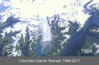
 Yesterday Google released a trove of timelapse images that offers, it believes, “the most comprehensive picture of our changing planet ever made available to the public.” Featuring a quarter-century of images taken from space by NASA and the U.S. Geological Survey, the repository lets you witness the retreat of glaciers (see above), the deforestation of wide swathes of rainforest, the growth of sprawling cities, and the building of huge artificial islands, all happening in timelapse motion.
To create its Timelapse website, Google “sifted through 2,068,467 images—a total of 909 terabytes of data—to find the highest-quality pixels … for every year since 1984 and for every spot on Earth.” They then used this data to create composite images for each year, all viewable in browsable HTML5 animation. Some striking images have also been posted on Google+.
via Google
Related Content:
Global Warming: A Free Course from UChicago Explains Climate Change
Perpetual Ocean: A Van Gogh-Like Visualization of our Ocean Currents
Harvard Thinks Green: Big Ideas from 6 All-Star Environment Profs
Excellent depth :-)