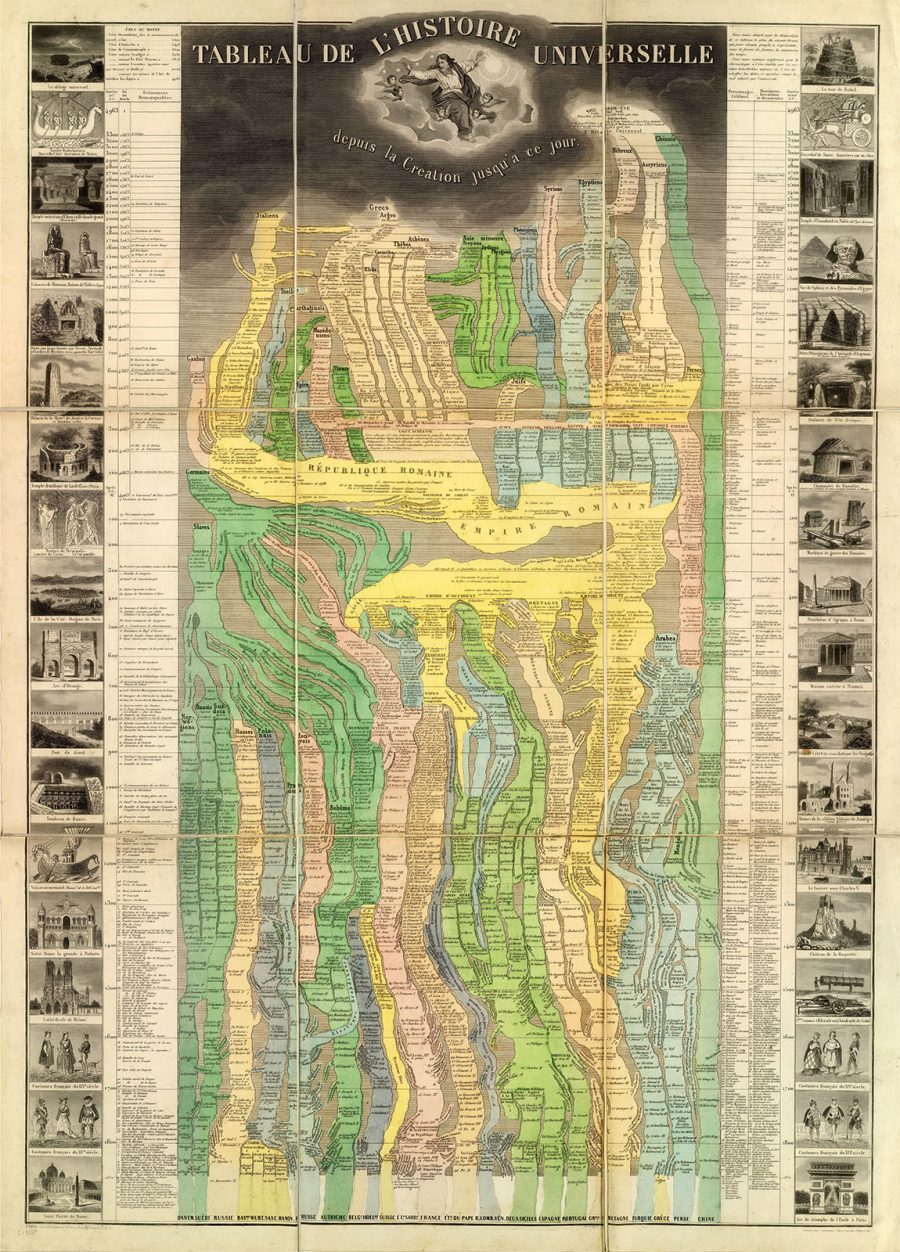
We start to understand history by listening to it told to us verbally, which lets us visualize it in our imagination. But how much more might we understand history if we could see it rendered visually right before our eyes? That question seems to have occupied the minds of certain of the cartographers of 19th-century Europe, those who wanted to take their craft beyond its traditional limits in order to do for chronology what it had long done for geography. Here we have one of the most glorious such attempts in existence, Eugene Pick’s 1858 Tableau De L’Histoire Universelle — or at least the half covering the civilizations of the Eastern Hemisphere — as held in the David Rumsey Map Collection.
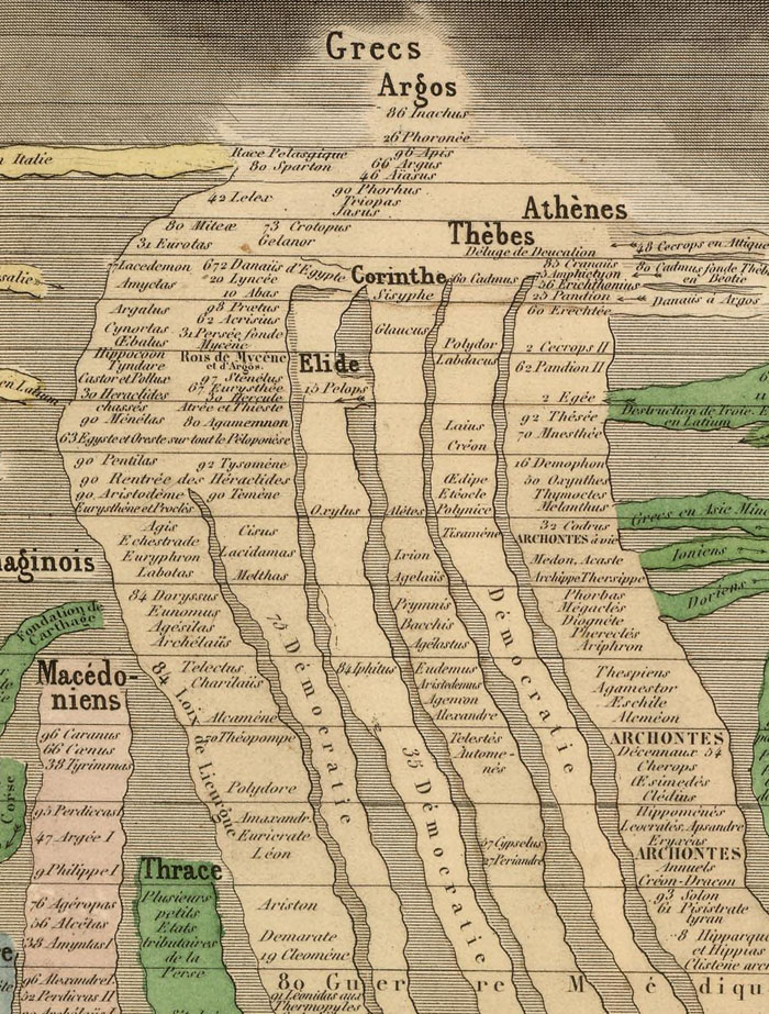
At first glance, all of the information on the map might appear overwhelming. But zoom in (looking at the center first, ideally from top to bottom) and you’ll soon grasp how Pick has depicted the history of the world, as a mid-19th-century Frenchman would conceive of it it, by drawing a kind of network of rivers and tributaries.
The “sources” of ancient civilizations, like those of the Greeks, the Phoenicians, the Egyptians, and the Chinese, flow down to those of various descendants — the Gauls, the Norwegians, the Russians, the Turks — and the mighty empires in which they pool, and arrive at the nations of the Danes, the Swedes, the Belgians, the Spanish, the Persians, and others besides. In total the map covers 6,000 years of history, moving from 4004 B.C. to 1856.
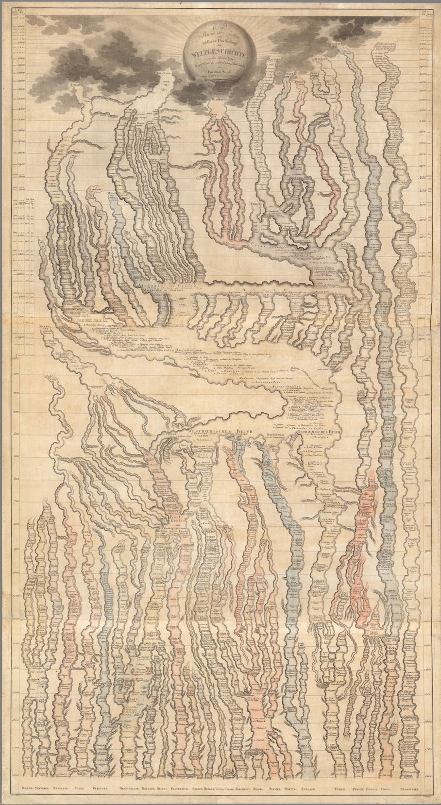
This technique of visualizing history has its precedents, including Friedrich Strass’ Der Strom der Zeiten oder bildliche Darstellung der Weltgeschichte, pictured just above (and later updated by American mapmaker Joseph Hutchins Colton as The Stream of Time in the 1840s and 1860s.) The David Rumsey Map Collection notes that, unlike Strass’ map, Pick’s also has “vignettes of people, buildings, historical scenes and important places in the history of the world” lined up on either side of the main content. It thus illuminates the abstract and continuous central rendering of history with representative, discrete ones, showing viewers everything from the Biblical flood and the Tower of Babel to the Great Sphinx of Giza and Agrippa’s Pantheon to Notre Dame and the Arc de Triomphe. It has a certain francocentrism, to be sure, but consider how many in Pick’s time considered France the center of humanity’s genius. Producing a map as compelling as this one couldn’t have diminished that image.
Based in Seoul, Colin Marshall writes and broadcasts on cities and culture. His projects include the book The Stateless City: a Walk through 21st-Century Los Angeles and the video series The City in Cinema. Follow him on Twitter at @colinmarshall or on Facebook.
As some of the finest fictional world-builders have understood, few things excite the imagination like a map. And despite the geographical limitation implied by its title, National Geographic’s maps have surveyed the entire globe and beyond. The magazine’s articles have not always presented an enlightened point of view, but for all its historical failings, the richly-illustrated monthly has excelled as a showcase for cartography, over which readers might spend hours, projecting themselves into unknown lands, journeying through the carefully-drawn topographies, cityscapes, and celestial charts.
Started as the official journal of the National Geographic Society, the magazine has amassed a huge, 130-year archive of “editorial cartography,” the National Geographic site writes. “Now, for the first time,” that collection is available online, “every map ever published in the magazine since the first issue of October 1888.”
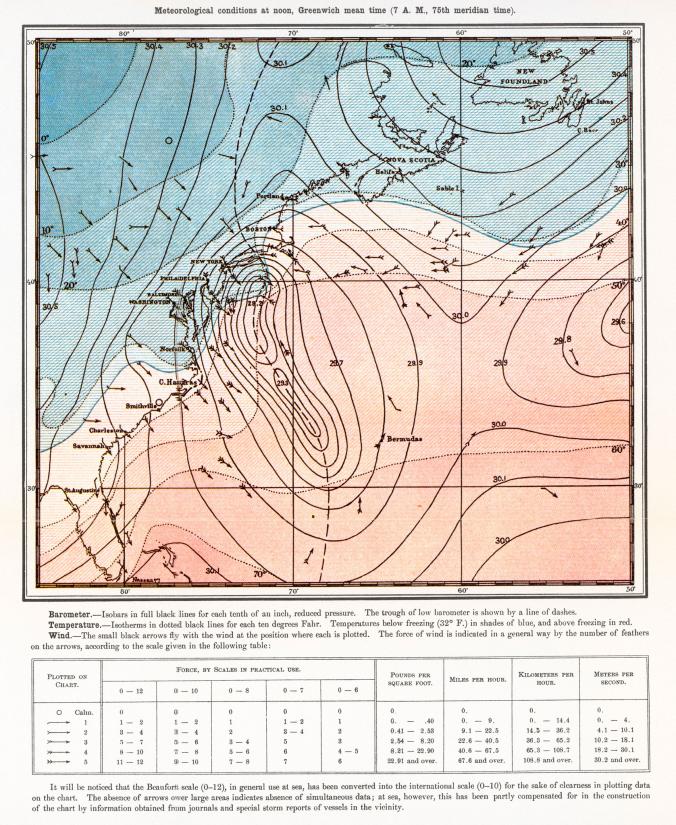
The entire archive is only available to subscribers (however you can find curated selections on the NatGeoMaps Twitter, Instagram, and Facebook accounts), but we can still see an astonishing quality and variety on display in dozens of maps on social media of every conceivable location, topic, and event, beginning with the very first published map, depicting the Great White Hurricane, “one of the most severe blizzards to ever hit the United States” (above)—the “start of a long tradition… of enhancing storytelling with maps.”
As longtime readers of National Geographic well know, the maps—often separable from the magazine in fold-outs suitable for hanging on the wall—function as more than visual aids. They tell their own stories. “A map is able to connect with somebody in a different way than a text will or a photo will,” notes the magazine’s director of cartography Martin Gamache. Maps “engage with a different part of our psyche or our brain.” From its earliest articulation, geography has inclined toward the poetic. The ancient geographer Strabo credited Homer as “the founder of geographical science,” who “reached the utmost limits of the earth, traversing it in his imagination.” Maps present us with a visual poetry often Homeric in its scope.
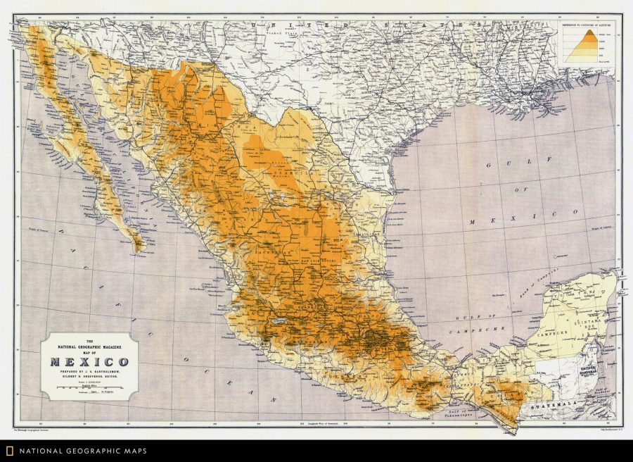
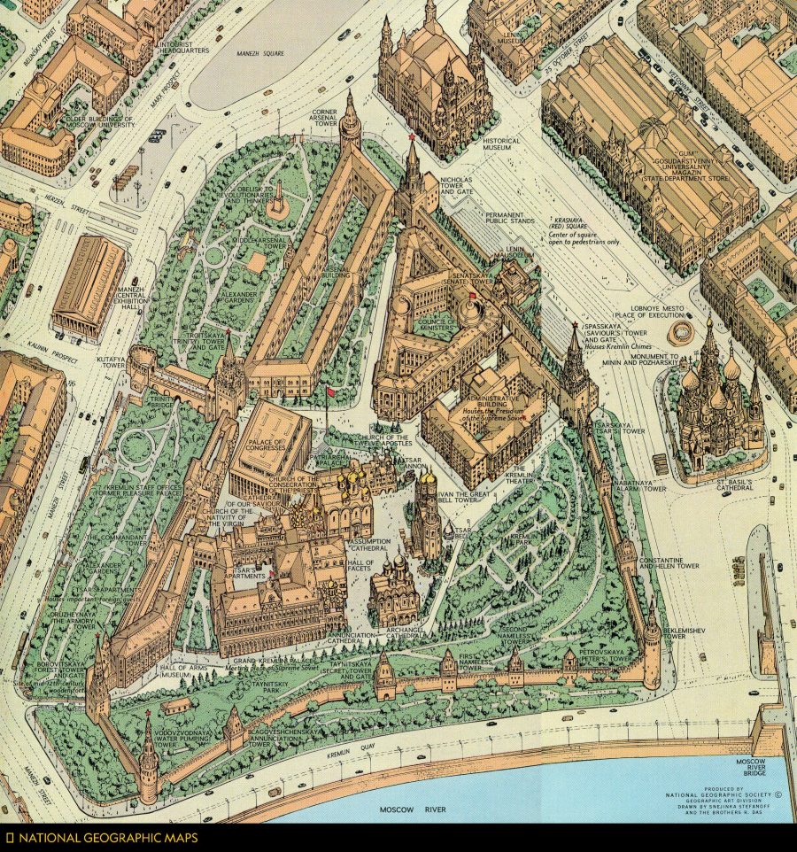
Though so many of these maps are detachable, it often helps to understand the specific context in which they were created, which doesn’t always appear in a self-contained legend. The map above, for example, published in March 1966, shows the Kremlin “in unprecedented detail,” as the magazine’s Twitter account points out: “Soviet regulations prohibited aerial photos, so artists collected diagrams and ground-level photos to draft a sketch that was brought to Moscow and corrected on the spot.” Further up, we see a map of Mexico from May 1914, “one of the first general reference maps of the country” from the National Geographic archive. The map at the top, from the December 1922 issue, is the magazine’s very first published general reference map of the world.
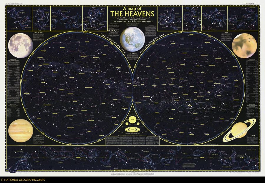
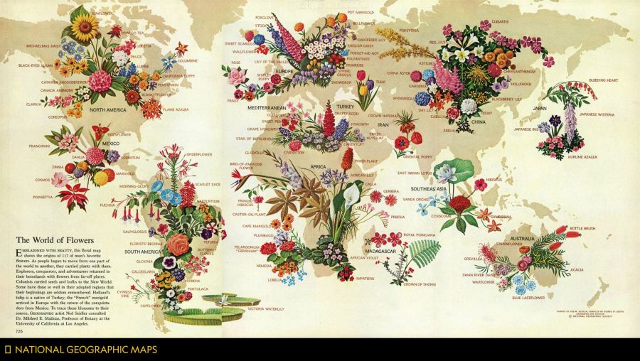
There are maps celestial, as above from 1957, and architectural—such as recent digital recreations of King Tut’s tomb, lately revealed to have no hidden chambers left to explore. Maps of planets beyond the solar system and planets (or “dwarf planets”) within it, such as this first published map of Pluto. Maps of rivers like the Rhine and spectacular natural formations like the Grand Canyon. There are even maps of flowers, like that published below in May 1968, showing “the origins of 117 types of blooms.” Some maps are much less joyous, like this recent series showing what the world might look like if all of the ice melted. Some are purely for fun, like this series on the geography of Star Wars and other fictional franchises.
If we can imagine it, National Geographic suggests, we can map it, and conversely, when we see a map, our imaginations are immediately engaged. Learn more at the NatGeo blog All Over the Map, and connect with many more curated maps from this huge collection at the magazine’s Twitter, Instagram, and Facebook accounts.
The Nazis may not have known art, but they knew what they liked, and much more so what they didn’t. We’ve previously featured here on Open Culture the “Degenerate Art Exhibition” of 1937, put on by Hitler’s party four years after it rose to power. Following on a show of only Nazi-approved works — including many depictions of classically Germanic landscapes, robust soldiers in action, blonde nudes — it toured the country with the intent of revealing to the German people the “insult to German feeling” committed by Entartete Kunst (Degenerate art), a Nazi-defined category of art created by the likes of Paul Klee, Wassily Kandinsky, Max Beckmann, George Grosz, and others, a roster heavy on the abstract, the expressionistic, and the Jewish.
“The list of more than 16,000 artworks was produced by the Reichsministerium für Volksaufklärung und Propaganda (Reich Ministry for Public Enlightenment and Propaganda) in 1942 or thereabouts. It seems that the inventory was compiled as a final record, after the sales and disposals of the confiscated art had been completed in the summer of 1941.”
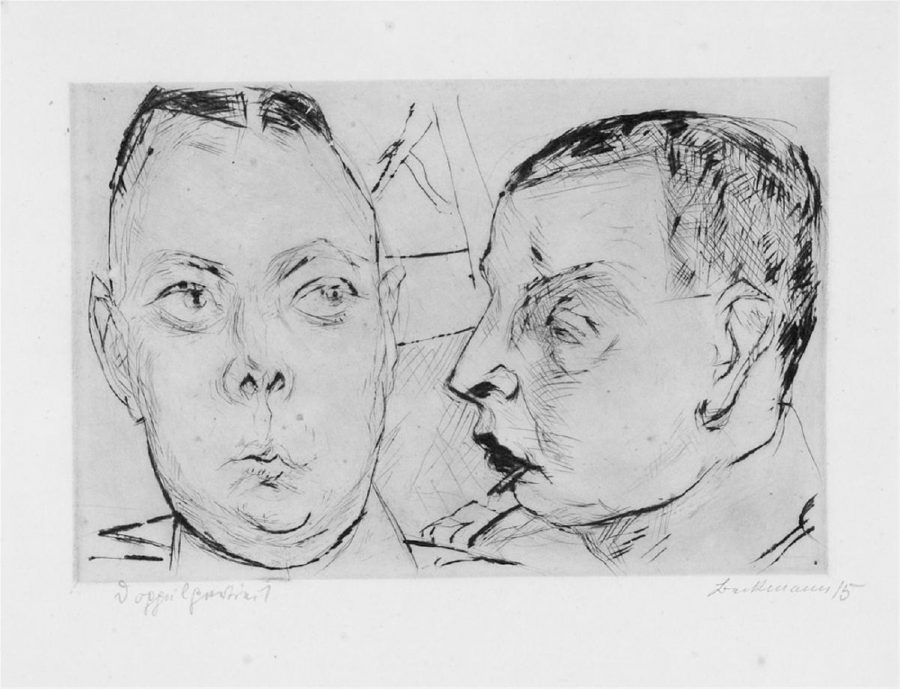
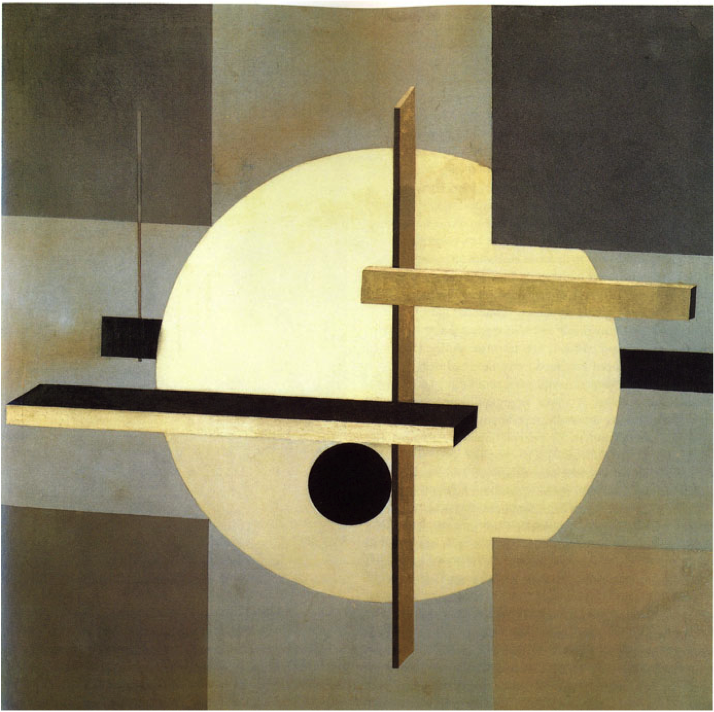
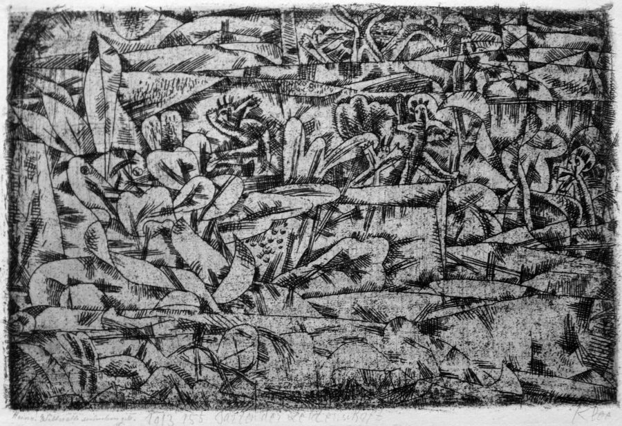
Daunting though the inventory itself may seem, Hyperallergic’s Jillian Steinhauer points out “a way to connect many of these pieces to the present day: an online database maintained by the Freie Universität Berlin. You can plug an artwork’s inventory number from the Nazi log books directly into their search engine, and it will pull up a record.” Here you see Max Beckmann’s Zwei Auto-Offiziere, El Lissitzky’s Proun R.V.N. 2, and Paul Klee’s Garten der Leidenschaft, just three examples of the thousands upon thousands of images that Hitler and company considered a threat to their regime. Today, the artistic merits of work by these and other artists once labeled Entartete Kunst have drawn more admirers than ever — though the very fact that the Nazis didn’t like it constitutes a decent reason for appreciation as well.
Based in Seoul, Colin Marshall writes and broadcasts on cities and culture. His projects include the book The Stateless City: a Walk through 21st-Century Los Angeles and the video series The City in Cinema. Follow him on Twitter at @colinmarshall or on Facebook.
Professor Einstein was surprised tonight into loud and long laughter.
Hollywood demonstrated its principles of “relativity,” how it makes things seem what they are not, by use of a dilapidated motor car.
At the First National studio, German technicians persuaded Professor Einstein to change his mind about not being photographed and photographed him in the old car with Frau Elsa, his wife. He cannot drive a car.
Tonight the German technicians brought the film to the Einstein bungalow. The lights went out.
Then the ancient automobile appeared on the screen with Einstein at the wheel, driving Frau Elsa on a sight-seeing tour.
Down Broadway, Los Angeles they drove, then to the beaches. Suddenly the car rose like an airplane, and as Einstein took one hand from the wheel to point out the scenery, the Rocky Mountains appeared below. Then the car landed on familiar soil and the drive continued through Germany.
It was just a Hollywood trick of double exposure and a thrilling comedy, but not for the public. The master film was destroyed, and the only copy was given to the Einsteins.
That one surviving copy of the film eventually ended up in the archives at Lincoln Center, where it sat unnoticed for decades, until Becca Bender, an archivist, stumbled up on it last year. And fortunately now we can all enjoy that light moment shot so long ago.
To learn more about the discovery of the 1931 film, watch the video below. Or read this article over at From the Grapevine.
If you would like to support the mission of Open Culture, consider making a donation to our site. It’s hard to rely 100% on ads, and your contributions will help us continue providing the best free cultural and educational materials to learners everywhere. You can contribute through PayPal, Patreon, and Venmo (@openculture). Thanks!
From time to time, Americans will talk about the mass killing, treaty-breaking, impoverishment, and forced removal or assimilation of Native peoples in the U.S. as “a shameful period in our history.” While this may sound like the noble acknowledgement of a genocidal crime, it is far too half-hearted and disingenuous, since these acts are central to the entirety of U.S. history, from the first landing of European ships on North American shores to the recent events at Standing Rock and beyond. An enormous body of scholarly and popular literature testifies to the facts.
For a thorough one-volume survey, see Roxanne Dunbar-Ortiz’s Indigenous Peoples’ History of the Unites States, a book that exhaustively cites several hundred years of well-documented events, like orders for extermination and land theft under military leaders George Washington, Andrew Jackson, and Army general Thomas S. Jesup. Dunbar-Ortiz shows how many U.S. military practices and terms (such as the phrase “in country”) came directly from the so-called “Indian Wars.”
Take the practice of “scalp hunting,” encouraged during the Pequot War and becoming routine throughout the period of New England settlement in the late 1600’s:
Bounties for Indigenous scalps were honored even in absence of war. Scalps and Indigenous children became means of exchange, currency, and this development may even have created a black market. Scalp hunting was not only a profitable privatized enterprise but also a means to eradicate or subjugate the Indigenous population of the Anglo-American Atlantic seaboard. The settlers gave a name to the mutilated and bloody corpses they left in the wake of scalp-hunts: redskins.
The American football team currently bearing that name and representing the nation’s capital, as Baxter Holmes shows at Esquire, pays tribute to the extreme brutality of murdering Indigenous people and using their scalps as cash. “This way of war,” writes Dunbar-Ortiz, “became the basis for the wars against the Indigenous across the continent into the late nineteenth century.”
In the GIF above, we see a dramatically telescoped visualization of the “violent seizing of Native Americans’ land” after 1776, writes Dylan Matthews at Vox, documented by historians like Dunbar-Ortiz and University of Georgia’s Claudio Saunt, who, along with Slate’s Rebecca Onion, created the graphic as a supplement for his book West of the Revolution: An Uncommon History of 1776. “The project’s source data,” write Saunt and Onion, “is a set of maps produced in 1899 by the Bureau of American Ethnology,” a Smithsonian research unit that “published and collected anthropological, archaeological, and linguistic research… as the nineteenth century drew to a close.”
Blue areas show Indigenous homelands, red areas show reservations. The “time-lapse function,” note the map’s creators, “is the most visually impressive aspect of this interactive,” but you can access a “deep level of detail” at the map’s site, such as the names of the hundreds of dispossessed and displaced nations and links to the historical documentation of their land “cession.”
Many of the boundaries are vague, write Saunt and Onion, “a broad approach that left a lot of room for creative implementation.” As Saunt puts it, “greater legality and more precision would have made it impossible to seize so much land in so short a time,” just over 100 years shown here, from the 1776 founding to 1887, during which over 1.5 billion acres were seized and occupied by frontier settlers and the U.S. army in what Saunt calls in the map’s title the “Invasion of America.”
In 1975, the philosopher of science Paul Feyerabend published his highly contrarian Against Method, a book in which he argued that “science is essentially an anarchic enterprise,” and as such, ought to be accorded no more privilege than any other way of knowing in a democratic society. Motivated by concerns about science as a domineering ideology, he argued the historical messiness of scientific practice, in which theories come about not through elegant logical thinking but often by complete accident, through copious trial and error, intuition, imagination, etc. Only in hindsight do we impose restrictions and tidy rules and narratives on revolutionary discoveries.
Several years later, in the third, 1993 edition of the book, Feyerebend observed with alarm the same widespread anti-science bias that Carl Sagan wrote of two years later in Demon-Haunted World. “Times have changed,” he wrote, “Considering some tendencies in U.S. education… and in the world at large I think that reason should now be given greater weight.”
Feyerabend died the following year, but I wonder how he might revise or qualify a 2018 edition of the book, or whether he would republish it at all. Politically-motivated science denialism reigns. Indeed, a blithe denial of any observable reality, aided by digital technology, has become a dystopian new norm. But as the philosopher also commented, such circumstances may “occur frequently today… but may disappear tomorrow.”
In the recorded history of human inquiry across cultures and civilizations, we see ideas we call scientific co-existing with what we recognize as pseudo- and anti-scientific notions. The differences aren’t always very clear at the time. And then, sometimes, they are. During the so-called Age of Reason, when the development of the modern sciences in Europe slowly eclipsed other modes of explanation, one obscure group of contrarians persisted in almost comically stubborn unreason. Calling themselves the Muggletonians, the Protestant sect—like those today who deny climate change and evolution—resisted an overwhelming consensus of empirical science, the Copernican view of the solar system, despite all available evidence the contrary. In so doing, they left behind a series of “beautiful celestial maps,” notes Greg Miller at National Geographic, some of which resemble William Blake’s visual poetry.
The sect began in 1651, when a London tailor named John Reeve “claimed to have received a message from God” naming his cousin Lodowicke Muggleton as the “’last messenger for a great work unto this bloody unbelieving world.’… One of the main principles of their faith, a later observer wrote, was that ‘There is no Devil but the unclean Reason of men.’” Their view of the universe, based, of course, on scripture, resembles the Medieval Catholic view that Galileo attempted to correct, but their principle antagonist was not the Italian polymath or the earlier Renaissance astronomer Copernicus, but the great scientific mind of the time, Isaac Newton, whom Muggletonians railed against into the 19th and even 20th century. Muggletonians, Miller writes,” had remarkable longevity—the last known member died in 1979 after donating the sect’s archive of books and papers… to the British Library.”
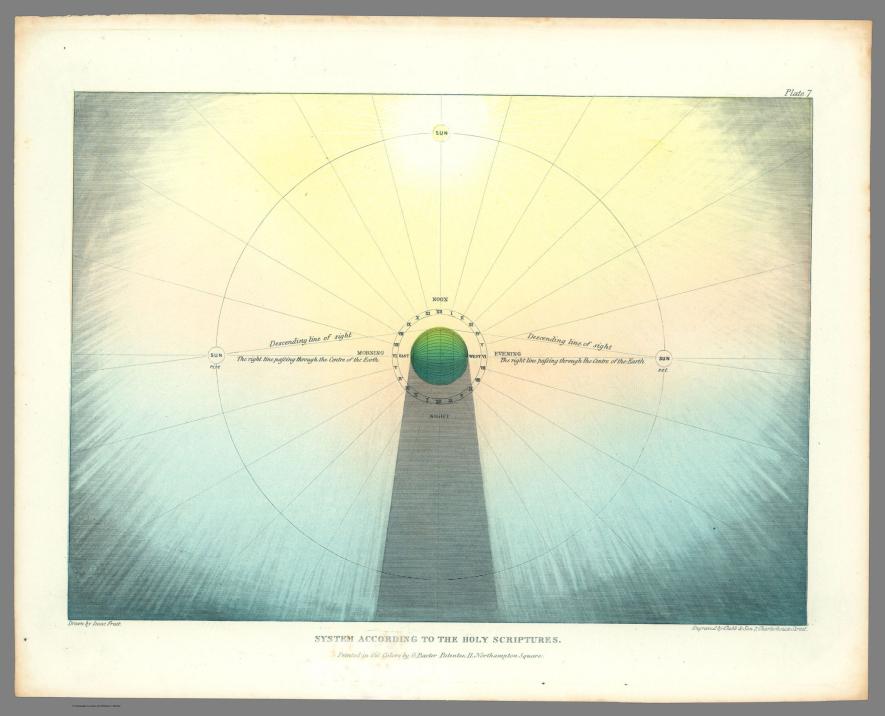
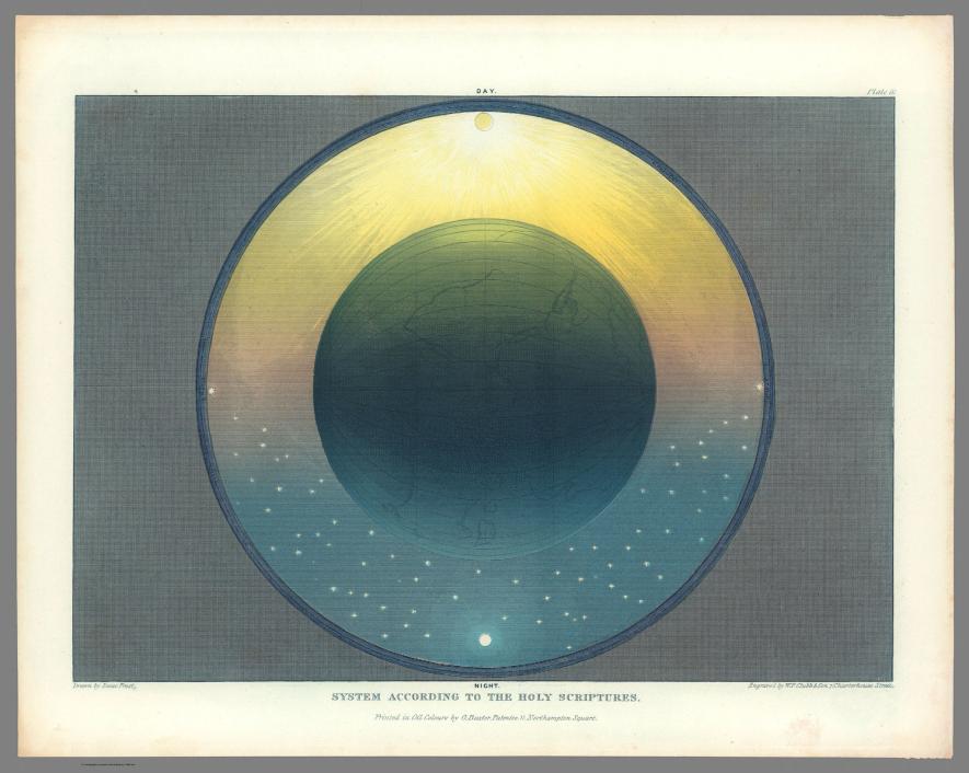
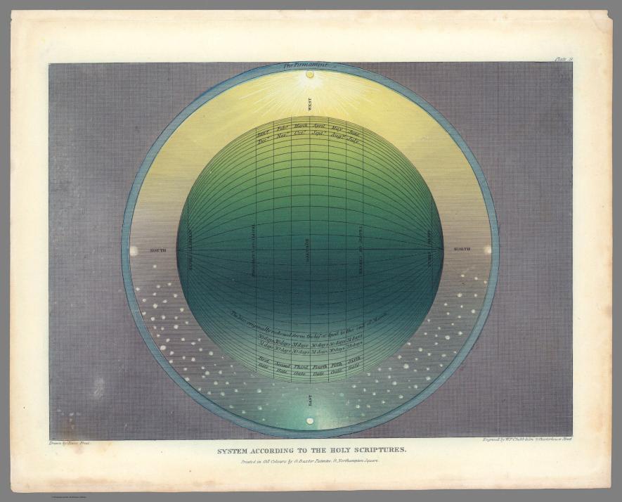
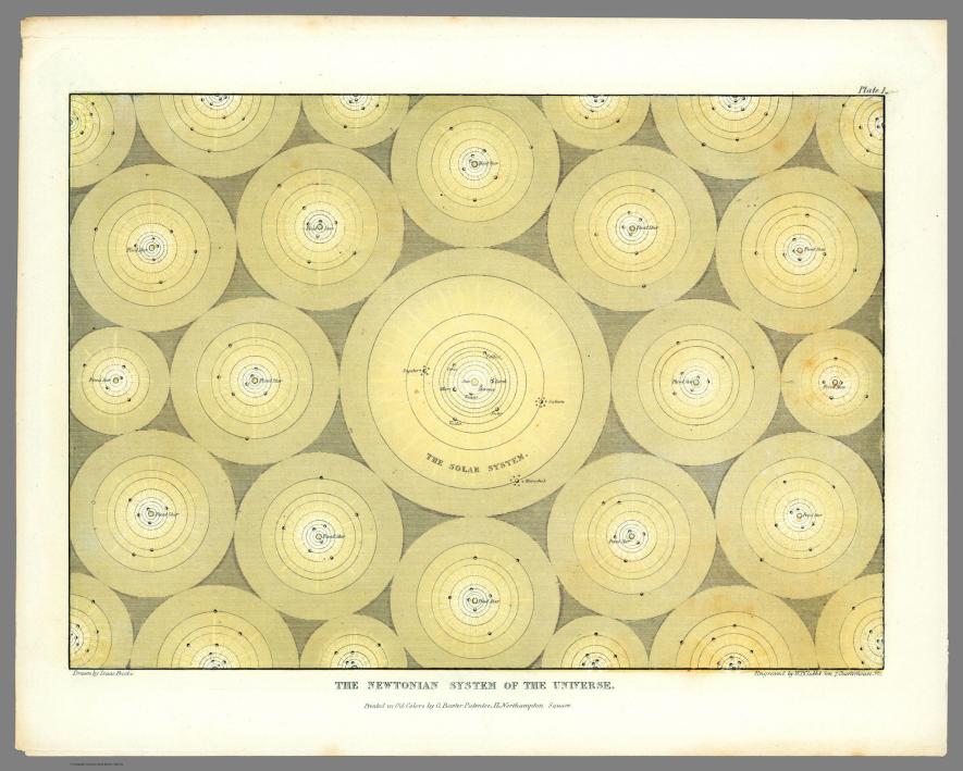
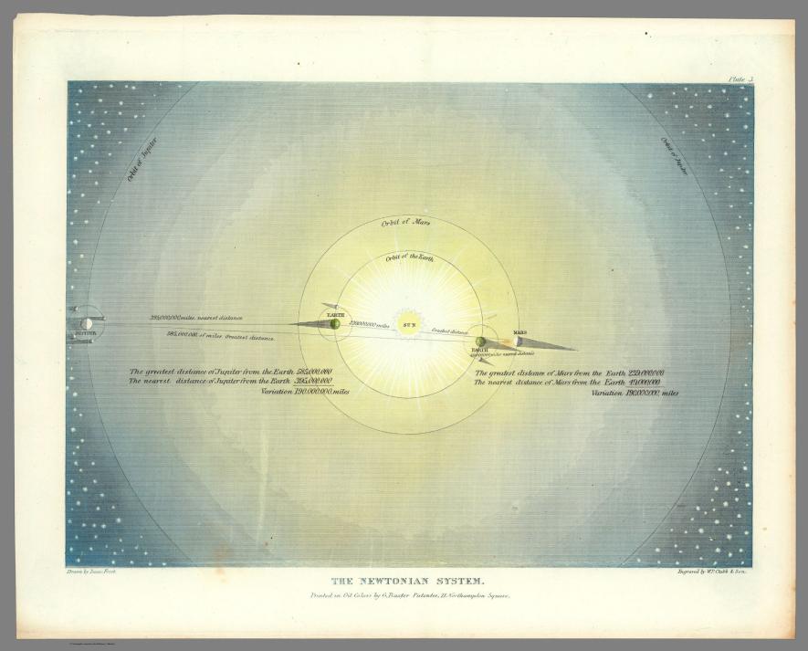
These plates come from an 1846 book called Two Systems of Astronomy. Written by Muggletonian Isaac Frost, it “pitted the scientific system of Isaac Newton—which held that the gravitational pull of the sun holds the Earth and other planets in orbit around it—against an Earth-centered universe based on a literal interpretation of the Bible.” The plate above, for example, “attempts to show the absurdity of the Newtonian system by depicting our solar system as one of many in an infinite and godless universe.” Ironically, in attempting to ridicule Newton (who was himself a pseudo-scientist and Biblical literalist in other ways), the Muggletonians stumbled upon the view of modern astronomers, who extrapolate a mind-boggling number of possible solar systems in an observable universe of over 100 billion galaxies (though these systems are not enclosed cells crammed together side-by-side). Another plate, below, shows Frost’s depiction of the hated Newtonian system, with the Earth, Mars, and Jupiter orbiting the Sun.
The other maps, further up, all represent the Muggletonian view. Historian of science Francis Reid describes it thus:
According to Frost, Scripture clearly states that the Sun, the Moon and the Stars are embedded in a firmament made of congealed water and revolve around the Earth, that Heaven has a physical reality above and beyond the stars, and that the planets and the Moon do not reflect the Sun’s rays but are themselves independent sources of light.
Frost gave lectures at “establishments set up for the education of artisans and other workmen.” It seems he didn’t attract much attention and was frequently heckled by audience members. Like flat earthers, Muggletonians were treated as cranks, and unlike today’s religious anti-science crusaders, they never had the power to influence public policy or education. For this reason, perhaps, it is easy to see them as quaintly humorous. Frost’s maps, as Miller writes, “remain strangely alluring” for both their artistic quality and their astonishingly determined credulity. The plates are now part of the massive David Rumsey collection, which houses thousands of rare historical maps. For another fascinating look at religious cartography, see Miller’s National Geographic post “mapping the Apocalypse.”
Back in 1915, French filmmakers decided to revisit the evolution of the bicycle during the 19th century, moving from the invention of the bicycle in 1818, to the bikes that emerged during the 1890s. As the resulting film above shows, the bike went from being clunky, cumbersome and seemingly perilous to ride, to taking on the tried and true shape that we still recognize today.
This film was preserved by the Netherlands’ EYE Film Institute. Hence the subtitles are in Dutch. But thanks to Aeon Magazine, you can read English translations below:
1. The draisine was invented only a century ago, in 1818 by Baron Drais de Sauerbrun.
2. [This subtitle never appears in the film.
3. The vehicle that lies between the draisine and the 1850 bicycle has an improved steering wheel and a fitted brake.
4. In 1863, Pierre Lallement invented pedals that worked on the front wheel.
5. Around 1868, a third wheel was added. Although these tricycles were heavier than the two-wheelers, they were safer.
6. Between 1867 and 1870, various improvements were made, including the increased use of rubber tyres.
7. In 1875, following an invention by the engineer Trieffault, the frame was made of hollow pipes.
8. Following the fashion of the day, the front wheel was made as large as possible.
9. In 1878, Renard created a bicycle with a wheel circumference of more than 7 feet. Just sitting down on one of these was an athletic feat!
11. At the beginning of 1879, Rousseau replaced the large front wheel with a smaller one, and the chain was introduced on the front wheel for driving power.
12. The bicycle of today.
For another look at the Birth of the Bike, you can watch a 1937 newsreel that gives its own narrative account. It comes the from British Pathé film archives.
If you would like to support the mission of Open Culture, consider making a donation to our site. It’s hard to rely 100% on ads, and your contributions will help us continue providing the best free cultural and educational materials to learners everywhere. You can contribute through PayPal, Patreon, and Venmo (@openculture). Thanks!
Somewhere within the Vatican exists the Vatican Secret Archives, whose 53 miles of shelving contains more than 600 collections of account books, official acts, papal correspondence, and other historical documents. Though its holdings date back to the eighth century, it has in the past few weeks come to worldwide attention. This has brought about all manner of jokes about the plot of Dan Brown’s next novel, but also important news about the technology of manuscript digitization. It seems a project to get the contents of the Vatican Secret Archives digitized and online has made great progress cracking a problem that once seemed impossibly difficult: turning handwriting into computer-searchable text.
In Codice Ratio is “developing a full-fledged system to automatically transcribe the contents of the manuscripts” that uses not the standard method of optical character recognition (OCR), which looks for the spaces between words, but a new way that can handle connected cursive and calligraphic letters. Their method, in the lingo of the field, “is to govern imprecise character segmentation by considering that correct segments are those that give rise to a sequence of characters that more likely compose a Latin word. We have designed a principled solution that relies on convolutional neural networks and statistical language models.”
This is a job, in other words, for artificial intelligence, but in partnership with human intelligence, a seldom-tapped source of which the scientists behind In Codice Ratio have harnessed: that of high-school students. Their special OCR software, writes the Atlantic’s Sam Kean, works by “dividing each word into a series of vertical and horizontal bands and looking for local minimums—the thinner portions, where there’s less ink (or really, fewer pixels). The software then carves the letters at these joints.” But the software “needs to know which groups of chunks represent real letters and which are bogus,” and so “the team recruited students at 24 schools in Italy to build the projects’ memory banks,” manually separating the letters the system had properly recognized from those over which it had stumbled.
And so the students became the system’s “teachers,” improving its ability to extract the content of handwriting, and not just handwriting but vast quantities of archaic handwriting, with every click they made. The encouraging results thus far mean that it probably won’t be long before large portions of the Vatican Secret Archives (which, contrary to its awkwardly translated name, is such a non-secret it even has its own official web site) will finally become easy to browse, search, copy, paste, and analyze. So they may, in the fullness of time, prove a fruitful resource indeed to writers of Catholicism-centric thrillers like Brown — who, after all, has already gone public with his enthusiasm for manuscript digitization.
Based in Seoul, Colin Marshall writes and broadcasts on cities and culture. His projects include the book The Stateless City: a Walk through 21st-Century Los Angeles and the video series The City in Cinema. Follow him on Twitter at @colinmarshall or on Facebook.
We're hoping to rely on loyal readers, rather than erratic ads. Please click the Donate button and support Open Culture. You can use Paypal, Venmo, Patreon, even Crypto! We thank you!
Open Culture scours the web for the best educational media. We find the free courses and audio books you need, the language lessons & educational videos you want, and plenty of enlightenment in between.


