“High tech and low life”: never have I heard a literary genre so elegantly encapsulated. I repeat it whenever a friend who finds out I enjoy reading cyberpunk novels — or watching cyberpunk movies, or playing cyberpunk video games — asks what “cyberpunk” actually means. We’ve all heard the word thrown around since the mid-1980s, and I seem to recall hearing it several times a day in the 1990s, when the development of the internet and its associated pieces of personal technology hit the accelerator hard. At the dawn of that decade, out came Cyberpunk, a primer on the eponymous movement in not just literature, film, and computers, but music, fashion, crime, punishment, and medicine as well. That time saw technology develop in such a way as to empower less governments, corporations, and other institutions than individual people: virtuous people, sketchy people, everyday people, and that favorite cyberpunk character type, the “gentleman-loser.”
We recently featured No Maps for These Territories, the 2000 documentary starring William Gibson, author of novels like Neuromancer, Idoru, and Pattern Recognition and the writer most closely associated with the cyberpunk movement. Cyberpunk describes him, a decade earlier, as “the man who may be said to have started it all,” and here he shares insights on how the literary form he pioneered made possible stylistic development within and the importation of elements of the wider literary and artistic world into the reactionary “golden ghetto” of the science-fiction industry. We also hear, amid a farrago of glossy, flamboyantly artificial early-1990s computer animation, from a number of cyberpunk-inclined artists, musicians, scientists, and hackers.
This lineup includes psychologist, LSD enthusiast, and Neuromancer PC game mastermind Timothy Leary, in some sense a progenitor of this whole culture of self-enhancement through technology. How has all this worked out in the near-quarter-century since? It depends on whether one of Gibson’s darker predictions aired here will come true: if things go wrong, he says, the future could in reality end up not as a grand personal empowerment but as “a very expensive American television commercial injected directly into your cortex.” Fortunately for cyberpunks the world over, we haven’t got there yet. Quite.
(And if this documentary gets you wanting to jump into cyberpunk literature, you could do worse than starting with Rudy Rucker’s Ware Tetralogy, two of whose books won the Philip K. Dick Award for best novel, all of which come with an introduction by Gibson, now available free online.)
Anyone remember Michael Crichton’s Westworld (or the Simpsonsparody)? In this dystopian 1973 sci-fi, tourists visit a triumvirate of fantasy theme parks staffed by robotic historical re-enactors: Roman World, Medieval World, and the titular West World, with its “lawless violence on the American Frontier.” When a virus infects the parks’ androids, James Brolin must fight a ruthless robot gunslinger—played by a stone-faced Yul Brenner—to the death. The film may look laughably dated, but the fears it taps into are anything but: 2001, Terminator, Battlestar Galactica, I, Robot, and even a Westworldremake in the works—the perennial theme of man vs. machine, as old in film at least as Fritz Lang’s silent Metropolis, becomes ever more relevant in our drone-haunted world.
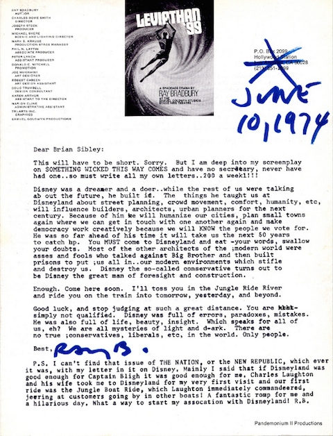
But are evil—or at least dangerously malfunctioning—robots something we should legitimately fear? Not according to visionary sci-fi author and Disney enthusiast Ray Bradbury in a letter to English writer Brian Sibley, penned in 1974, one year after the release of theme-park horror Westworld. The main body of Bradbury’s letter consists of a vigorous defense of Walt Disney and Disneyland, against whom “most of the other architects of the modern world were asses and fools.” Sibley recalls that his initial letter “expressed doubts about Disney’s use of Audio-Animatronic creations in Disneyland.” “At the time,” he explains, “I… had probably read too many sci-fi stories about the danger of robots taking over our human world—including, of course, some by Ray—and so saw it as a sinister rather than benign experiment.”
After his praise of Disney, Bradbury writes two agitated postscripts exploding what Sibley calls “ill-informed and prejudiced views” on robots. He classes automated entities with benign “extensions of people” like books, film projectors, cars, and presumably all other forms of technology. Notwithstanding the fact that books cannot actually wield weapons and kill people, Bradbury makes an interesting argument about fears of robots as akin to those that lead to censorship and enforced ignorance. But Bradbury’s counterclaim sounds a misanthropic note that nonetheless rings true given the salient examples he offers: “I am not afraid of robots,” he states, emphatically, “I am afraid of people, people, people.” He goes on to list just a few of the conflicts in which humans kill humans, religious, racial, nationalist, etc.: “Catholics killing Protestants… whites killing blacks… English killing Irish.…” It’s a short sampling that could go on indefinitely. Bradbury strongly implies that the fears we project onto robotic bogeymen are in reality well-grounded fears of each other. People, he suggests, can be monstrous when they don’t “remain human,” and technology—including robots—only assists with the necessary task of “humanizing” us. “Robots?” Bradbury writes, “God, I love them. And I will use them humanely to teach all of the above.”
Read a transcript of the letter below, courtesy of Letters of Note, and be sure to check out that site’s new book-length collection of fascinating historical correspondence.
June 10, 1974
Dear Brian Sibley:
This will have to be short. Sorry. But I am deep into my screenplay on SOMETHING WICKED THIS WAY COMES and have no secretary, never have had one..so must write all my own letters..200 a weekl!!!
Disney was a dreamer and a doer..while the rest of us were talking ab out the future, he built it. The things he taught us at Disneyland about street planning, crowd movement, comfort, humanity, etc, will influence builders architects, urban planners for the next century. Because of him we will humanize our cities, plan small towns again where we can get in touch with one another again and make democracy work creatively because we will KNOW the people we vote for. He was so far ahead of his time it will take is the next 50 years to catch up. You MUST come to Disneyland and eat your words, swallow your doubts. Most of the other architects of the modern world were asses and fools who talked against Big Brother and then built prisons to put us all up in..our modern environments which stifle and destroy us. Disney the so-called conservative turns out to be Disney the great man of foresight and construction.
Enough. Come here soon. I’ll toss you in the Jungle Ride River and ride you on the train into tomorrow, yesterday, and beyond.
Good luck, and stop judging at such a great distance. You are simply not qualified. Disney was full of errors, paradoxes, mistakes. He was also full of life, beauty, insight. Which speaks for all of us, eh? We are all mysteries of light and dark. There are no true conservatives, liberals, etc, in the world. Only people.
Best,
(Signed, ‘Ray B.’)
P.S. I can’t find that issue of THE NATION, of the NEW REPUBLIC, which ever it was, with my letter in it on Disney. Mainly I said that if Disneyland was good enough for Captain Bligh it was good enough for me. Charles Laughton and his wife took me to Disneyland for my very first visit and our first ride was the Jungle Boat Ride, which Laughton immediately commandeered, jeering at customers going by in other boats! A fantastic romp for me and a hilarious day. What a way to start my association with Disneyland! R.B.
P.S. Can’t resist commenting on you fears of the Disney robots. Why aren’t you afraid of books, then? The fact is, of course, that people have been afraid of books, down through history. They are extensions of people, not people themselves. Any machine, any robot, is the sum total of the ways we use it. Why not knock down all robot camera devices and the means for reproducing the stuff that goes into such devices, things called projectors in theatres? A motion picture projector is a non-humanoid robot which repeats truths which we inject into it. Is it inhuman? Yes. Does it project human truths to humanize us more often than not? Yes.
The excuse could be made that we should burn all books because some books are dreadful.
We should mash all cars because some cars get in accidents because of the people driving them.
We should burn down all the theatres in the world because some films are trash, drivel.
So it is finally with the robots you say you fear. Why fear something? Why not create with it? Why not build robot teachers to help out in schools where teaching certain subjects is a bore for EVERYONE? Why not have Plato sitting in your Greek Class answering jolly questions about his Republic? I would love to experiment with that. I am not afraid of robots. I am afraid of people, people, people. I want them to remain human. I can help keep them human with the wise and lovely use of books, films, robots, and my own mind, hands, and heart.
I am afraid of Catholics killing Protestants and vice versa.
I am afraid of whites killing blacks and vice versa.
I am afraid of English killing Irish and vice versa.
I am afraid of young killing old and vice versa.
I am afraid of Communists killing Capitalists and vice versa.
But…robots? God, I love them. I will use them humanely to teach all of the above. My voice will speak out of them, and it will be a damned nice voice.
Unmanned aerial vehicles, more colloquially known as drones, have drawn bad press in recent years: as the intrusive tools of the coming surveillance state, as deliverers of death from above in a host of war zones, as the purchase-delivering harbingers of world domination by Amazon.com. But as with any technology, you can also use drones for the good, or at least for the interesting. A number of urban photographers have attracted a great deal of attention in the past few months doing just that, buying or building camera-equipped drones of their own, taking to the skies above their cities, and capturing views of them we’d never see otherwise. I live in Los Angeles and like to think I explore its ever-more-revitalized downtown (from which I type this post) on a regular basis, but nearly every shot Ian Wood got in the early morning with his drone in the video above shows off an aesthetic element of the neighborhood I hadn’t noticed before.
Those of you who know Bangkok might feel startled to get the highly unusual view of it, nearly free of people provided by Coconuts TV, who took a camera drone out on a day when protesters shut down seven of the city’s most vital intersections. (It reminds me of a few favorite moments by that most celebrated Thai “auteur of languor,” Apichatpong Weerasethakul.) But you may have noticed that all the videos here focus on depopulated places, due most likely to the tricky host of applicable laws to do with privacy and aerial photography. So if you decide to film a drone flythrough of your own city, perhaps have a chat with your lawyer first.
“I probably worry less about the real future than the average person,” says William Gibson, the man who coined the term “cyberspace” and wrote books like Neuromancer, Idoru, and Pattern Recognition. These have become classics of a science-fiction subgenre branded as “cyberpunk,” a label that seems to pain Gibson himself. “A snappy label and a manifesto would have been two of the very last things on my own career want list,” he says to David Wallace-Wells in a 2011 Paris Review interview. Yet the popularity of the concept of cyberspace — and, to a great extent, its having become a reality — still astonishes him. “I saw it go from the yellow legal pad to the Oxford English Dictionary, but cyberspace is everywhere now, having everted and colonized the world. It starts to sound kind of ridiculous to speak of cyberspace as being somewhere else.” A dozen years earlier, in Mark Neale’s biographical documentary No Maps for These Territories, the author tells of how he first conceived it as “an effective buzzword,” “evocative and essentially meaningless,” and observes that, today, the prefix “cyber-” has very nearly gone the way of “electro-”: just as we’ve long since taken electrification for granted, so we now take connected computerization for granted.
“Now,” of course, means the year 1999, when Neale shot the movie’s footage. He did it almost entirely in the back of a limousine, tricked out for communication and media production, that carried Gibson on a road trip across North America. The long ride gives us an extended look into Gibson’s curious, far-reaching mind as he explores issues of the inevitability with which we find ourselves “penetrated and co-opted” by our technology; growing up in a time when “the future with a capital F was very much a going concern in North America”; the loss of “the non-mediated world,” a country to which we now “cannot find our way back”; the modern reality’s combination of “a pervasive sense of loss” and a Christmas morning-like “excitement about what we could be gaining”; his early go-nowhere pastiches of J.G. Ballard and how he then wrote Neuromancer as an approach to the “viable but essentially derelict form” of science fiction; his fascination with the sheer improbability of those machines known as cities; and his mission not to explain our moment, but to “make it accessible,” finding the vast, near-incomprehensible structure underlying the pounding waves of thought, trend, and technology through which we all move. Watching No Maps for These Territories here in cyberspace, I kept forgetting that Gibson said these things a tech-time eternity ago, so pertinent do they sound to thismoment. And happiness, as he puts it in one aside, “is being in the moment.”
My “In Ulysses” project is another way of experiencing the book — this time, using the virtual format. It will be a virtual reality videogame that will allow a user to inhabit the characters of Ulysses and experience the density of Joyce’s language in a fun and accessible way.…
As a user of “In Ulysses” walks along a virtual Sandymount Strand, the book will be read to them — they will hear Stephen’s thoughts as they are written — but these thoughts will then be illustrated around the user in real-time using textual annotations, images and links. A user can stop walking (therefore stopping Stephen walking) and explore these illustrations, gaining insight into the book and adding to the enjoyment of it.
“In Ulysses” has already raised €4000, enough to fund its prototype. No target date for its release has been announced. And, from what I can tell, the consumer version of the Oculus Rift won’t be released until next year. So, like any good reader of Ulysses, you’ll need to have a little patience.
Looking to kill some time during the dog days of summer? Here’s one option that John Ptak came up with. On his intriguing blog, The History of Ideas, he writes: “Isn’t this great? I bumped into a wonderful site called kloth.net that provides a free-to-all and unrestricted use of their punch card emulator. It was found while looking for dating ideas for an IBM 5081 card that I have that has programming information for the BINAC computer (ca. late 1940’s), and kloth.net had info on the history of IBM cards as well as the emulator–plus other stuff. Completely distracted from the BINAC quest, I created some cards using some great first lines of literature. You can play too!” I created two of my own, using The American Book Review’s list of 100 great opening lines.
What exactly is a punch card, our younger readers might rightly ask? An IBM web site tells us:
Perhaps the earliest icon of the Information Age was a simple punched card produced by IBM, commonly known as the “IBM card.” Measuring just 7- 3/8 inches by 3- 1/4 inches, the piece of smooth stock paper was unassuming, to be sure. But taken collectively, the IBM card [like the floppy disks that came later] held nearly all of the world’s known information for just under half a century—an impressive feat even by today’s measures. It rose to popularity during the Great Depression and quickly became a ubiquitous installment in the worlds of data processing and popular culture. What’s more, the punched card [see examples from Columbia University here] provided such a significant profit stream that it was instrumental to IBM’s rapid growth in the mid-twentieth century.
Maybe you knew about Marcel Duchamp’s passion for chess. But did you know about Marlon Brando’s passion for conga drums? Longtime fans may have first picked up on it in 1955, when the actor gave a microwave-link television tour of his Hollywood Hills home to Edward R. Murrow on Person to Person. Halfway through the segment (above), Brando gets into his history with the instrument, and even offers to “run downstairs and give you a lick or two” — and the always highly-prepared program had cameras in the conga room ready to capture this “impromptu” performance. While the interests actors keep on the side may tend to wane, Brando’s seems to have waxed, and later in life he even, writes Movieline’s Jen Yamato, “enlisted the help of Latin jazz percussionist Poncho Sanchez while developing a new tuning system for conga drums.” We can behold the extent and seriousness of Brando’s pursuit of conga perfection with a look at one of those patents, filed in 2002, for an automatic “drumhead tensioning device and method.”
As The Atlantic’s Rebecca Greenfield explains in a post on “Patents of the Rich and Famous,” “tightening a drum takes a lot of effort. Once the drum head loses its tension, there are typically six separate rods that need tightening. Far too many rods for Marlon. Brando explains that others have tried to develop mechanisms that would improve the drum tightening experience but none of them provided a simple or affordable solution.” Hence his motorized “simple and inexpensive drum tuning device that is also accurate and reliable and not subject to inadvertent adjustments.” And if you have no need for an automatic conga drum tuner, perhaps we can interest you in another of Brando’s achievements? “He had these shoes that you can wear in the pool, that would increase friction as you walk on the bottom of the pool to give you a better workout,” says patent attorney Kevin Costanza in an NPR story on Brando’s inventions. Or maybe you’d prefer to simply watch The Godfather again.
We're hoping to rely on loyal readers, rather than erratic ads. Please click the Donate button and support Open Culture. You can use Paypal, Venmo, Patreon, even Crypto! We thank you!
Open Culture scours the web for the best educational media. We find the free courses and audio books you need, the language lessons & educational videos you want, and plenty of enlightenment in between.