
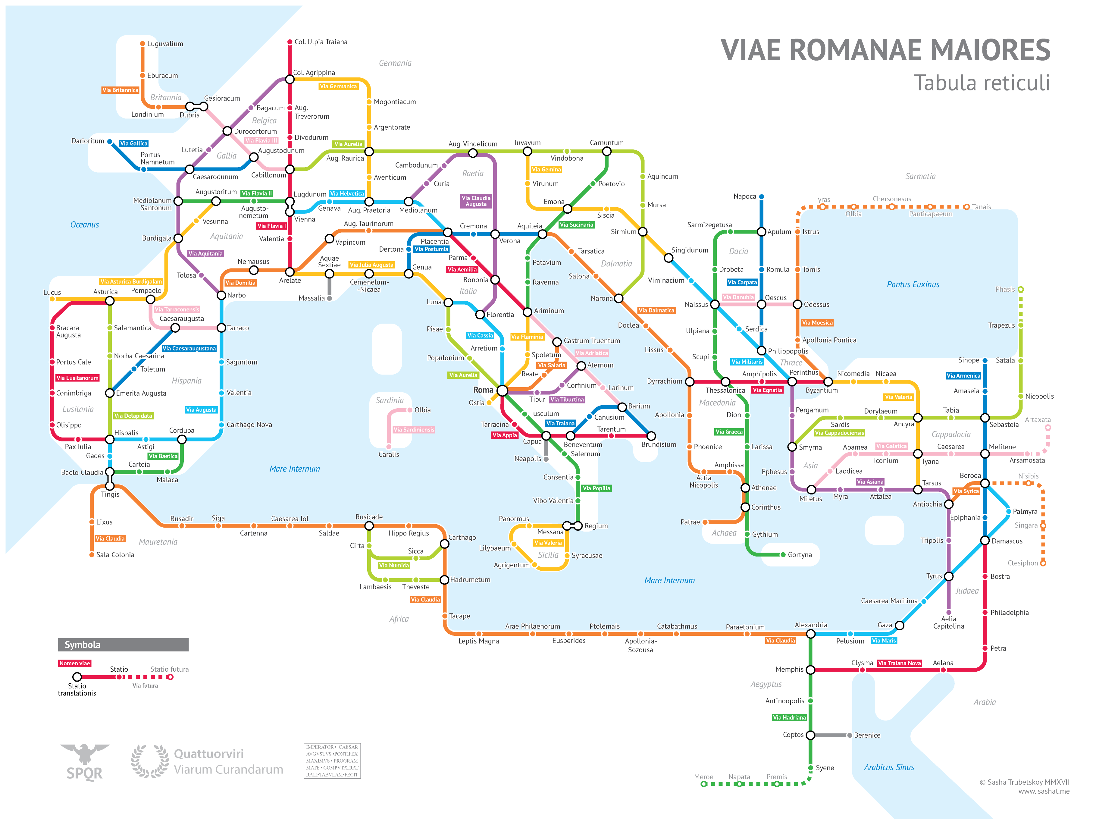
Sasha Trubetskoy, formerly an undergrad at U. Chicago, has created a “subway-style diagram of the major Roman roads, based on the Empire of ca. 125 AD.” Drawing on Stanford’s ORBIS model, The Pelagios Project, and the Antonine Itinerary, Trubetskoy’s map combines well-known historic roads, like the Via Appia, with lesser-known ones (in somes cases given imagined names). If you want to get a sense of scale, it would take, Trubetskoy tells us, “two months to walk on foot from Rome to Byzantium. If you had a horse, it would only take you a month.”
You can view the map in a larger format here. And if you follow this link and send Trubetskoy a few bucks, he can email you a crisp PDF for printing. Find more focused, related maps by Trubetskoy right here:
- The Roman Roads of Britain Visualized as a Subway Map
- The Roman Roads of Spain & Portugal Visualized as a Subway Map: Ancient History Meets Modern Graphic Design
- All the Roman Roads of Italy, Visualized as a Modern Subway Map
If you would like to support the mission of Open Culture, consider making a donation to our site. It’s hard to rely 100% on ads, and your contributions will help us continue providing the best free cultural and educational materials to learners everywhere. You can contribute through PayPal, Patreon, and Venmo (@openculture). Thanks!
Related Content:
The Roman Roads and Bridges You Can Still Travel Today
An Interactive Map Shows Just How Many Roads Actually Lead to Rome
How to Make Roman Concrete, One of Human Civilization’s Longest-Lasting Building Materials
Its a pity it’s not provided in a format where it can be downloaded easily as there are numerous gamers and historians who would really appreciate this resource.
Sadly it looks like it will be available only if you pay for it, and I suspect that will not be cheap.
Thats disappointing. Oh well back to the current resources.
It’s very interesting to hear and read about it. And a small question, how I can actually download those maps?
It is cheap at $9 — I’m sure that’s no problem for serious historians or game developers. People who actually appreciate Trubetskoy’s work should be fine paying that. Plus, this article does provide a free high-rez version
Don’t pay the 9, make your own with this ad reference :) def not worth the 9 hah