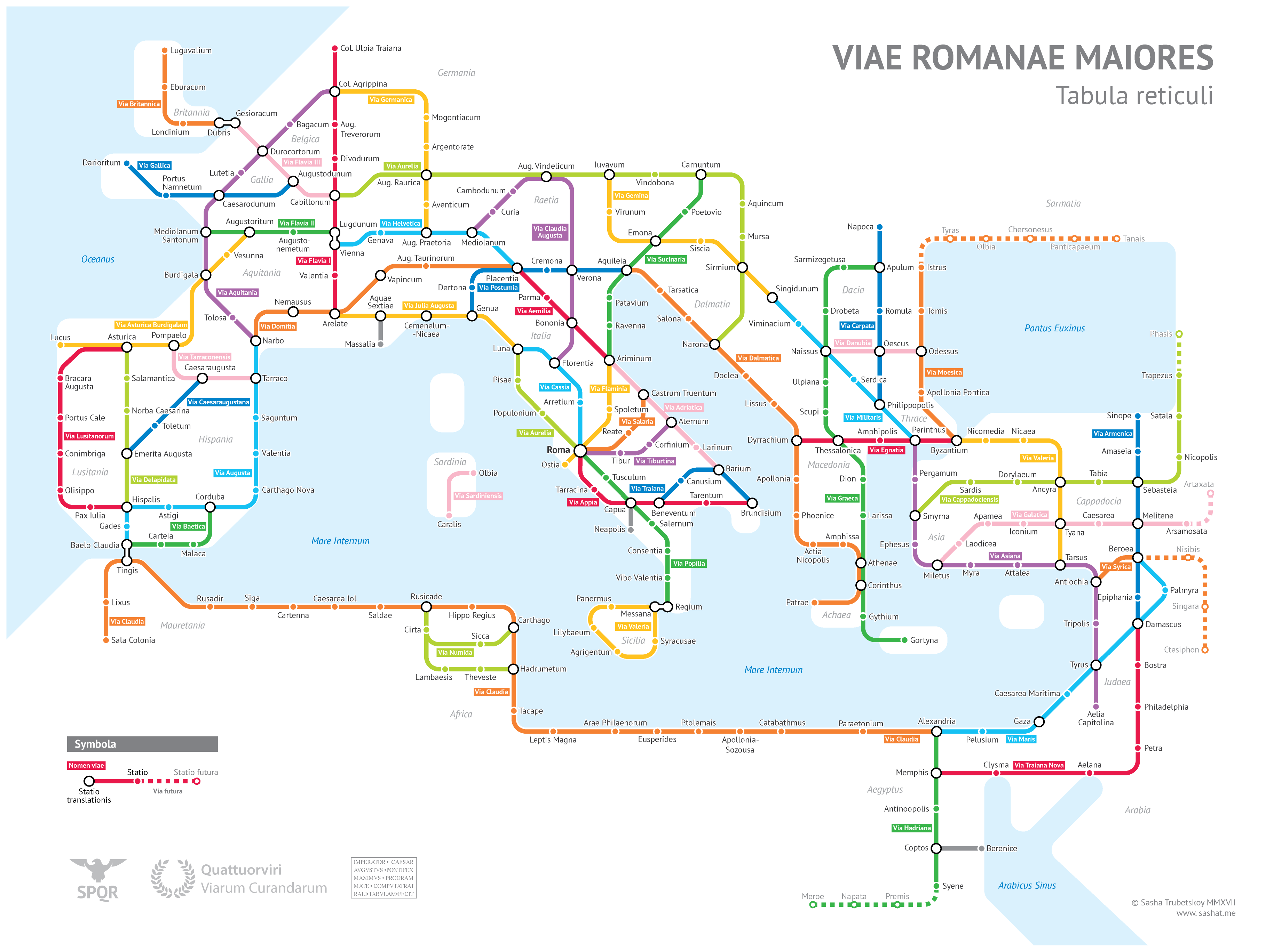
Sasha Trubetskoy, an undergrad at U. Chicago, has created a “subway-style diagram of the major Roman roads, based on the Empire of ca. 125 AD.” Drawing on Stanford’s ORBIS model, The Pelagios Project, and the Antonine Itinerary, Trubetskoy’s map combines well-known historic roads, like the Via Appia, with lesser-known ones (in somes cases given imagined names). If you want to get a sense of scale, it would take, Trubetskoy tells us, “two months to walk on foot from Rome to Byzantium. If you had a horse, it would only take you a month.”
If you would like to support the mission of Open Culture, consider making a donation to our site. It’s hard to rely 100% on ads, and your contributions will help us continue providing the best free cultural and educational materials to learners everywhere. You can contribute through PayPal, Patreon, and Venmo (@openculture). Thanks!
You can’t make a perfectly accurate map, as Jorge Luis Borges so succinctly told us, without making it the exact same size and shape as the land it portrays. But given the utter uselessness of such an enormous piece of paper (which so frustrated the citizens of the imaginary empire in Borges’ story that, “not without some pitilessness,” they tossed theirs into the desert), no mapmaker would ever want to. A more compact map is a more useful one; unfortunately, a more compact map is also, by its very nature, a less accurate one.
New York
The same rule applies to maps of all kinds, and especially to transit maps, quite possibly the most useful specialized maps we consult today. They show us how to navigate cities, and yet their clean, bold lines, sometimes turning but never wavering, hardly represent those cities — subject as they are to variations in terrain and density, as well as centuries of unplannably organic growth — with geographical faithfulness. One can’t help but wonder just how each urban transit map, some of them beloved works of design, strikes the usefulness-faithfulness balance.
London
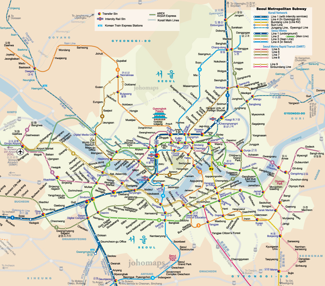
Living in Seoul, I’ve grown used to the city’s standard subway map. I thus get a kick out of scrutinizing the more geographically accurate one, which overlays the train lines onto an existing map of the city, posted on some station platforms. It reveals the truth that some lines are shorter than they look on the standard map, some are much longer, and none cut quite as clean a path through the city as they seem to. At Twisted Sifter you’ll find a GIF gallery of 15 standard subway maps that morph into more geographically faithful equivalents, a vivid demonstration of just how much transit map designers need to twist, squeeze, and simplify an urban landscape to produce something legible at a glance.
Tokyo
All of those animations, just five of which you see in this post, come from the subreddit Data Is Beautiful, a realm populated by enthusiasts of the visual display of quantitative information — enthusiasts so enthusiastic that many of them create innovative data visualizations like these by themselves. According to their creations, subway maps, like that of New York City’s venerable system, do relatively little to distort the city; others, like Tokyo’s, look nearly unrecognizable when made to conform to geography.
Austin
Even the maps of new and incomplete transit networks do a number on the real shape and direction of their paths: the map of Austin, Texas’ Capital MetroRail, for instance, straightens a somewhat zig-zaggy northeast-southwest track into a single horizontal line. It may take a few generations before Austin’s “system” develops into one extensive and complex enough to inspire one of the great transit maps (the ranks, for example, of “The Wonderground Map of London Town”). But I wouldn’t count out the possibility: the more fully cities realize their public-transit potential, the more opportunity opens up for the advancement of the subway mapmaker’s art.
Last year, a Yale-led research project produced an innovative dataset that mapped the history of urban settlements. Covering a 6,000 year period, the project traced the location and size of cities across the world, starting in 3700 BC (when the first known urban dwellings emerged in Sumer) and continuing through 2000 AD. According to Yale’s Meredith Reba, if we understand “how cities have grown and changed over time, throughout history, it might tell us something useful about how they are changing today,” and particularly whether we can find ways to make modern cities sustainable.
The Yale dataset was originally published in Scientific Data in 2016. And before too long, some enterprising YouTuber brought the data to life. Above, the history of urban life unfolds before your eyes. The action starts off slow, but then later kicks into high gear.
If you would like to support the mission of Open Culture, consider making a donation to our site. It’s hard to rely 100% on ads, and your contributions will help us continue providing the best free cultural and educational materials to learners everywhere. You can contribute through PayPal, Patreon, and Venmo (@openculture). Thanks!
As a way of currying favor with a monarch, Johannes Klencke’s gift to Charles II (1630–1685) was one of the most audacious and beautiful objects ever offered. Klencke was a Dutch sugar merchant and knew that the king loved maps, and hoped that his gift would land him a favorable trading deal. (It did. He got knighted.)
The above video, which the British Library posted by way of Daniel Crouch Rare Books, shows a time-lapse of the multiple day shoot, which took several people, a very large room, several lights, and a specially designed stand to hold the heavy volume.
The public domain images are now part of the Library’s Picturing Places website, which holds many examples of rare maps, landscapes, and large scale technical drawings.
The book itself, as huge as it might be, is actually very fragile, so now the public and scholars can fully explore these maps at leisure while the original goes back into storage.
Ted Mills is a freelance writer on the arts who currently hosts the artist interview-based FunkZone Podcast and is the producer of KCRW’s Curious Coast. You can also follow him on Twitter at @tedmills, read his other arts writing at tedmills.com and/or watch his films here.
These days everyone’s hung up on identity. But I don’t mean to talk politics, though my point is maybe inescapably political: the identities our jobs and incomes give us—the status or lack thereof—become so central to who we are in the world that they eclipse other essential aspects, eclipse the things we do strictly because it gives us pleasure to do them.
Music, dance, art, poetry.… These fall under what Alan Lomax called an experience of “the very core” of existence, “the adaptive style” of culture, “which enables its members to cohere and survive.” Culture, for Lomax, was neither an economic activity nor a racial category, neither an exclusive ranking of hierarchies nor a redoubt for nationalist insecurities. Cultures, plural, were peculiarly regional expressions of shared humanity across one interrelated world.
Lomax did have some paternalistic attitudes toward what he called “weaker peoples,” noting that “the role of the folklorist is that of the advocate of the folk.” But his advocacy was not based in theories of supremacy but of history. We could mend the ruptures of the past by adding “cultural equity… to the humane condition of liberty, freedom of speech and religion, and social justice,” wrote the idealistic Lomax. “The stuff of folklore,” he wrote elsewhere, “the orally transmitted wisdom, art and music of the people, can provide ten thousand bridges across which men of all nations may stride to say, ‘You are my brother.’”
Lomax’s idealism may seem to us quaint at best, but I dare you to condemn its results, which include connecting Lead Belly and Woody Guthrie to their global audiences and preserving a good deal of the folk music heritage of the world through tireless field and studio recording, documentation and memoir, and institutions like the Association for Cultural Equity (ACE), founded by Lomax in 1986 to centralize and make available the vast amount of material he had collected over the decades.
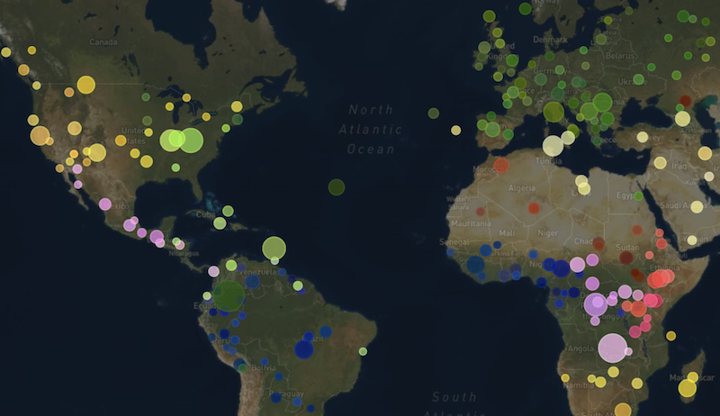
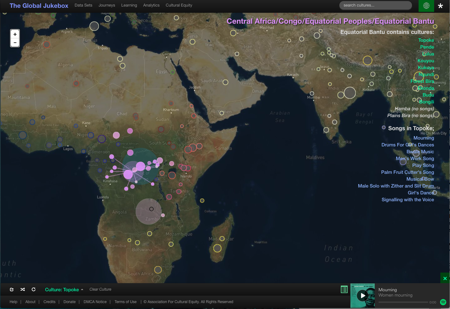
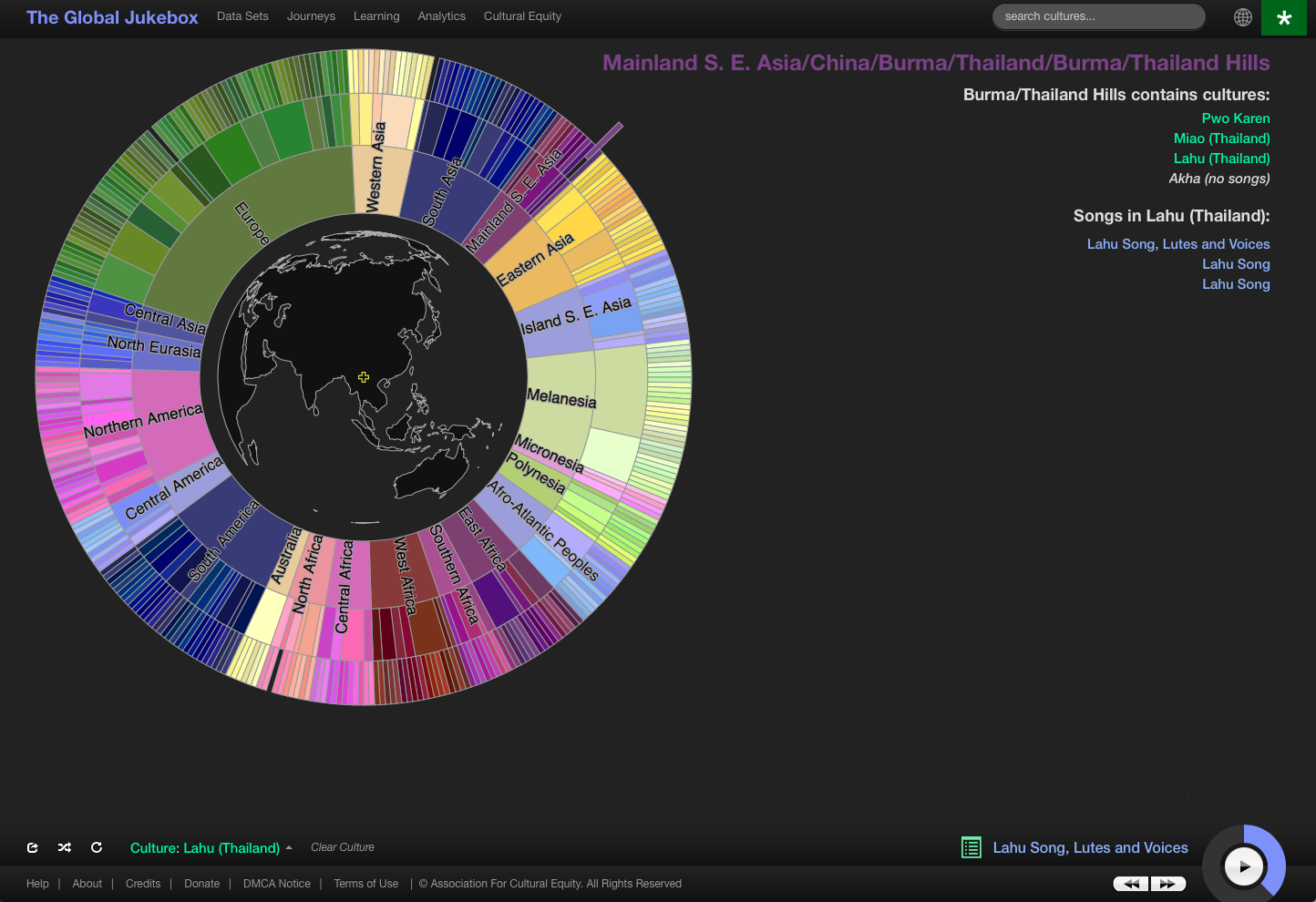
In another archival project, Lomax’s Global Jukebox, we get to see rigorous scholarly methods applied to examples from his vast library of human expressions. The online project catalogues the work in musicology of Lomax and his father John, who both took on a “life long mission to document not only America’s cultural roots, but the world’s as well,” notes an online brochure for the Global Jukebox. Lomax believed that “music, dance and folklore of all traditions have equal value” and are equally worthy of study. The Global Jukebox carries that belief into the 21st century.
Since 1990, the Global Jukebox has functioned as a digital repository of music from Lomax’s global archive, as you can see in the very dated 1998 video above, featuring ACE director Gideon D’Arcangelo. Now, updated and put online, the newly-launched Global Jukeboxweb site provides an interactive interface, giving you access to detailed analyses of folk music from all over the world, and highly technical “descriptive data” for each song. You can learn the systems of “Choreometrics and Cantometrics”—specialized analytical tools for scientists—or you can casually browse the incredible diversity of music as a layperson, through a beautifully rendered map view or the colorfully attractive graphic “tree view,” below.
Stop by the Global Jukebox’s “About” page to learn much more about its technical specificities and history, which dates to 1960 when Lomax began working with anthropologist Conrad Arensberg at Columbia and Hunter Universities to study “the expressive arts” with scientific tools and emerging technologies. The Global Jukebox represents a highly schematic way of looking at Lomax’s body of work, and its ease of use and level of detail make it easy to leap around the world, sampling the thrilling variety of folk music he collected.
It is not, and is not meant as, a substitute for the living traditions Lomax helped safeguard, and the incredible music they have inspired professional and amateur musicians to make over the years. But the Global Jukebox gives us several unique ways of organizing and discovering those traditions—ways that are still evolving, such as a coming function for building your own cultural family tree with a playlist of songs from your musical ancestry.
One of the greatest challenges for writers and greatest joys for readers of fantasy and science fiction is what we call “world building,” the art of creating cities, countries, continents, planets, galaxies, and whole universes to people with warring factions and nomadic truth seekers. Such writing is the natural offspring of the Medieval travelogue, a genre once taken not as fantasy but fact, when sailors, crusaders, pilgrims, merchants, and mercenaries set out to chart, trade for, and convert, and conquer the world, and returned home with outlandish tales of glittering empires and people with faces in their chests or hopping around on a single foot so big they could use it to shade themselves.
One of the most famous of such chroniclers, Sir John Mandeville, may now be mostly forgotten, but for centuries his Travels was so popular with aspiring navigators and literary men like Shakespeare, Milton, and Keats that “until the Victorian era,” writes Giles Milton, it was he, “not Chaucer, who was known as ‘the father of English prose.’”
Mandeville, like Marco Polo half a century before him, may have been part adventurer, part charlatan, but in any case, both drew their itineraries, as did later navigators like Columbus and Walter Raleigh, from a very long tradition: the making of speculative world maps, which far predates the early Middle Ages of pilgrimage and thirst for Eastern spices and gold.
In the Western tradition, we can trace world mapmaking all the way back to 6th century B.C.E., Pre-Socratic thinker Anaximander, student of Thales, whom Aristotle regarded as the first Greek philosopher. We have no copy of the map, but we have some idea what it might have looked since Herodotus described it in detail, a circular known world sitting atop an earth the shape of a drum. (Anaximander was also an original speculative astronomer.) His map contained two continents, or halves, “Europe” and “Asia”—which included the known countries of North Africa. “Two relatively small strips of land north and south of the Mediterranean Sea,” with ten inhabited regions in total, that illustrate the very early dichotomizing of the world—in this case divided top to bottom rather than west and east.
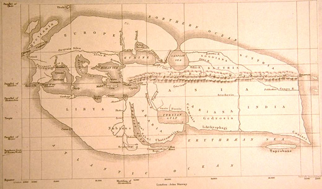
Anaximander may have been the first Greek geographer, but it is the 2nd century B.C.E. that Libyan-Greek scientist and philosopher Eratosthenes who has historically been given the title “Father of Geography” for his three-volume Geography, his discovery that the earth is round, and his accurate calculation of its circumference. Lost to history, Eratosthenes’ Geography has been pieced together from descriptions by Roman authors, as has his map of the world—at the top in a 19th-century reconstruction—showing a contiguous inhabited landmass resembling a lobster claw.
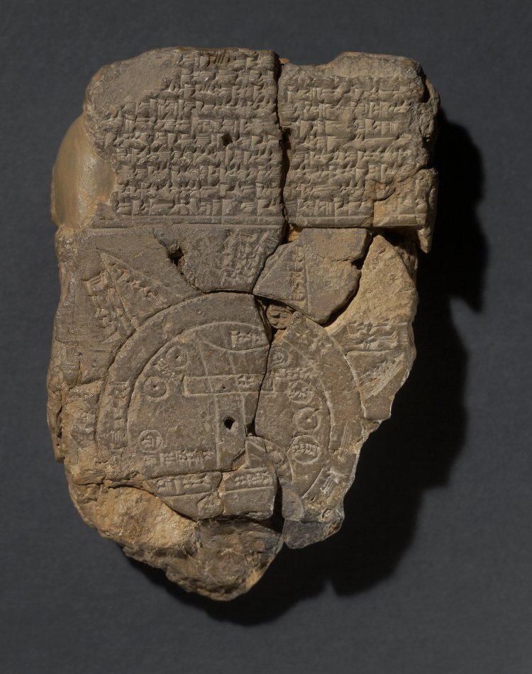
You’ll note that Eratosthenes drew primarily on Anaximander’s description of the world. In turn, his map had a significant influence on later Medieval geographers. A Babylonian world map, inscribed on a clay tablet around the time Anaximander imagined the world (and thought to be the earliest extant example of such a thing), may have influenced European map-making in the age of discovery as well. It depicts a flat, round world, with Babylon at the center (see the British Museum for a detailed translation and commentary of the map’s legend).
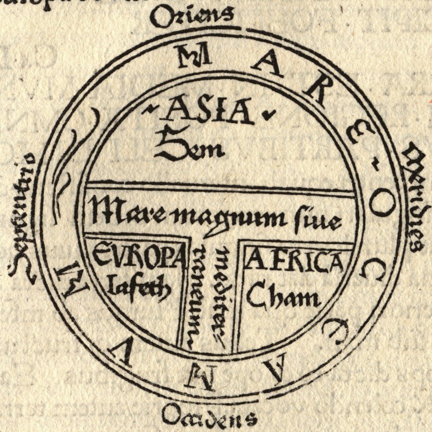
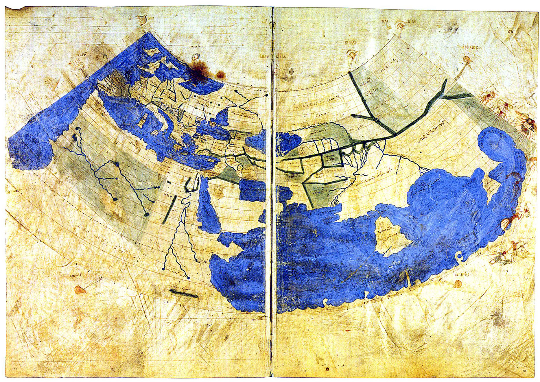
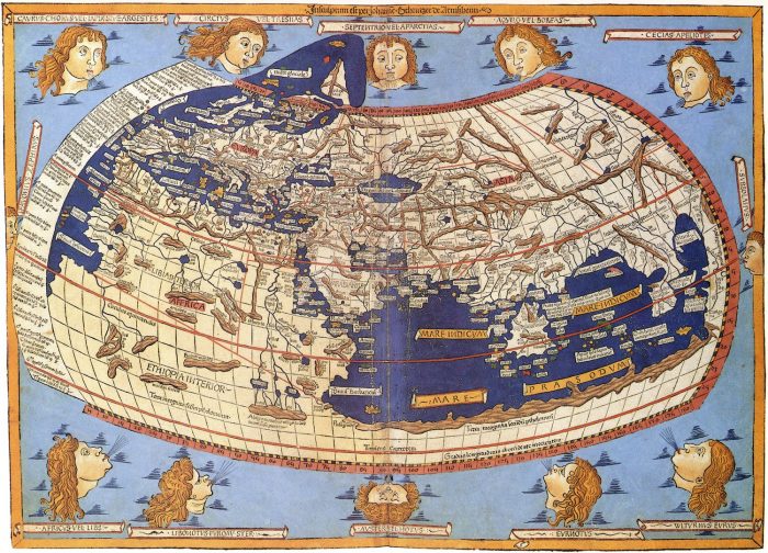
The Babylonian map is said to survive in the similar-looking “T and O map” (third image from top), representing the words orbis terrarium and originating from descriptions in 7th century C.E. Spanish scholar Isadora of Seville’s Etymologiae. The “T” is the Mediterranean and the “O” the ocean. In the version above, a recreation of an 8th century drawing, and every derivation thereafter, we see the three known continents, Asia, Europe, and Africa, with the holy city, Jerusalem, at the center. This map greatly informed early Medieval conceptions of the world, from crusaders to garrulous knights errant like Mandeville, and raconteur merchants like Polo, both of whom made quite an impression on Columbus and Raleigh, as did the circa 1300 map from Constantinople above, the oldest of many drawn from the thousands of coordinates in Roman geographer and astronomer Ptolemy’s Geographia.
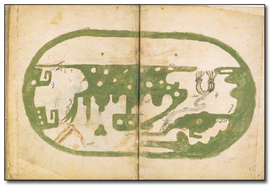
It wouldn’t be until 100 years after the translation of Ptolemy’s text from Greek to Latin in 1407 that his geographical precision became widely known. Until this, “all knowledge of these co-ordinates had been lost in the West,” writes the British Library. This would not be so in the East, however, where world maps like Ibn Hawqal’s, above from 980 C.E., show the influence of Ptolemy, already so long dominant in geography in the Islamic world that it was beginning to wane. Many more world maps survive from 11–12th century Britain, Turkey, and Sicily, from 16th century Korea, and from that wandering age of Columbus and Raleigh, beginning to increasingly resemble the world maps we’re familiar with today. (See a 15th century reconstruction of Ptolemy’s geography below.)
For most of recorded history, knowledge of the world from any one place in it was almost wholly or partly speculative and imaginative, often peopled with monsters and wonders. “All cultures have always believed that the map they valorize is real and true and objective and transparent,” as Jerry Brotton Professor at Queen Mary University of London tells Uri Friedman at The Atlantic. Columbus believed in his speculative maps, even when he ran into islands off the coast of continents charted on none of them. We are still conceptual prisoners—or consumers, users, readers, viewers, audiences—of maps, though we’ve physically plotted every corner of the globe. Perspectives cannot be rendered objective. No gods-eye views exist.
Nonetheless, several culturally formative projections of the world since Ptolemy’s Geography and well before it have changed the whole world, pointing to the power of human imagination and the legendarily imaginative, as well as legendarily brutal, acts of “world building” in real life.
Whether we like to admit it or not, the history of the U.S. is in great degree a history of genocide and racist terror. As Roxanne Dunbar-Ortiz has demonstrated in An Indigenous Peoples’ History of the United States, the phrase “Manifest Destiny”—which we generally associate with the second half of the 19th century—accurately describes the nation’s ethos since well before its founding. The idea that the entire continent belonged by right of “Providence” to a highly specific group of European settlers is what we often hear spoken of now of as “white nationalism,” an ideology that has been as violent and bloody as certain other nationalisms, and in many ways much more so.
“Somehow,” writes Dunbar-Ortiz, “even ‘genocide’ seems an inadequate description for what happened” to the Native American nations. Martin Luther King, Jr. recognized this history as inseparable from the struggles of African-Americans and other groups, writing in 1963’s Why We Can’t Wait, “our nation was born in genocide when it embraced the doctrine that the original American, the Indian, was an inferior race. Even before there were large numbers of Negroes on our shores, the scar of racial hatred had already disfigured colonial society. From the sixteenth century forward, blood flowed in battles of racial supremacy.”
One striking commonality—or rather continuity—in the histories Dunbar-Ortiz and King tell is that a huge number of violent attacks on Native and Black people, slave and free, were carried out by ordinary settlers and citizens, unofficially deputized by the state as irregular enforcers of white supremacy. Especially in the century after the Civil War, white nationalism took the form of lynchings: brutal vigilante hangings, burnings, and mutilations meant to terrorize communities of color and enact the kind of frontier “justice” pioneered on the actual frontier. Most of the recorded victims were African-American, but “Native Americans, as well as Mexican, Chinese, and Italian workers were brutalized and murdered” as well, writes Laura Bliss at Citylab, and “although the rural South was by far the bloodiest region nationally, no area was really safe.”
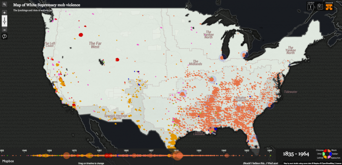
Now, a new interactive map—named Monroe Work Today after the early 20th century historian (Monroe Nathan Work) who gathered much of the data—“aims to be the most comprehensive catalogue of proven lynchings that took place in the United States from 1835 to 1964.” The site calls its impressive map “a rebirth of one piece” of Monroe Work’s legacy, expanded to include many more sources and the post WWII period. “In the century after the Civil War,” write the map’s creators, “as many as 5000 people of color were executed—not by courts, but by mobs on the street who believed the cause of white supremacy.”
Lynchings became widespread in the early 1800s, “as a form of self-appointed justice in local communities… when townspeople made grave accusations first, but never bothered to gather proof.” In the postbellum U.S., such killings became more exclusively racialized in “very real crusades to change the United States to a place only for whites.” Local leaders “encouraged people to carry that idea onto the streets.” As you can see in the screenshots here from particularly violent periods in history, most, but by no means all of these extrajudicial killings took place in the South against African Americans.
In other areas of density in the Southwest, “Far West,” and “Left Coast” (as the project refers to these areas) the victims tended to be Latino/a, Chinese, or Native American. In New Orleans, a deep pool of blue marks the many Sicilian victims of lynching in the late 19th century.
For a number of reasons discussed on the site, the map’s creators caution against using their tool “to decide that some places suffered ‘more racism’ than others.” Many other forms of racist violence, from intimidation to rape, redlining, criminalization, and job discrimination have been widespread around the country and are not shown on the map. In anticipation of accusations of bias, Monroe Work Todayencourages users to evaluate the source for themselves. (“You should always do this with anything you read online.”) A good place to start would be their extensive bibliography. As you scroll through the site, you’ll find other questions answered as well.
Writing at The Smithsonian, Danny Lewis calls the map “an important endeavor to help mark these dark parts of American history and make it more visible and accessible for all.” But Monroe Work Today is more than a research tool. The site bears witness to a continuing story. “The threat of violence for Americans of color is alive and real,” writes Bliss, “This is a good time to revisit its history.”
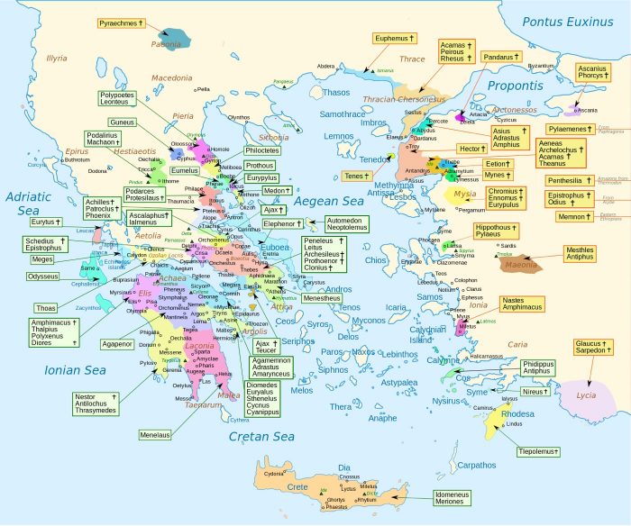
You’ve adjusted to the strangeness of names like Ascalaphus and Phidippus. You’ve more or less figured out who’s on which side in the ancient war between Greece and Troy. But as literary epics will do—from the ancient Greeks and Indians to the 19th century Russians—Homer’s Iliad also presents you with several logistical puzzles you must either ignore or spend countless hours trying to solve: you are given the names of major and minor characters’ hometowns, ranging all over the Adriatic, Ionian, Cretan, and Aegean Seas. Doubtless you have no idea where most of these places were.
Again and again, place names occur in rapid succession, and you’re told not only who hails from where, but who commands and conquers which city. Just a smattering of examples from Book II (in Samuel Butler’s translation):
Ulysses led the brave Cephallenians, who held Ithaca, Neritum with its forests, Crocylea, rugged Aegilips, Samos and Zacynthus, with the mainland also that was over against the islands.
Thoas, son of Andraemon, commanded the Aetolians, who dwelt in Pleuron, Olenus, Pylene, Chalcis by the sea, and rocky Calydon,
And those that held Pherae by the Boebean lake, with Boebe, Glaphyrae, and the populous city of Iolcus
“Huh,” you say, “Okay, Homer, I’ll take your word for it.” Questions of historicity aside, we can at least say that the hundreds of cities and towns mentioned in this culturally formative text did exist, or continue to do so, though it’s debatable, as Jason Kottke writes, whether “that level of mobility was accurate for the time [somewhere in the 11th or 12th century BC] or if Homer simply populated his poem with folks from all over Greece as a way of making listeners from many areas feel connected to the story.”
In any case, you need not despair of ever making sense of Homer’s bewildering geographical lists. The map above (click here to see it in a larger format) handily illustrates the world of the Iliad, showing the places of origins of a few dozen characters, with Greeks in green and Trojans in yellow. Kottke notes in an addendum to his post that “not every character is represented… (particularly the women) and… some of the locations and hometowns are incorrect.” We would welcome corrections—as would Wikipedia—if an enterprising classics scholar has the time and energy to devote to such an effort.
But for the lay reader of Homer’s epic, the map more than suffices as helpful visual context for a very complicated narrative. One defining feature of a war epic well-told, most critics would say, is that the human drama does not get lost in the scale and scope of the action. More than any other form, the epic illustrates what Tolstoy described in War and Peace as the “historical sense” that our conflicts are “bound up with the whole course of history and preordained from all eternity.” But against this kind of determinism, the great poets particularize, making their characters seem not like props in a cosmic drama but like actual people from actual places on earth. Seeing the Iliad mapped above reinforces our sense of the Greek epics as genuine—if fantastical—accounts of meaningful human action in the world.
You can find free versions of the Iliad and the Odyssey in our collection of Free eBooks and Free Audio Books.
We're hoping to rely on loyal readers, rather than erratic ads. Please click the Donate button and support Open Culture. You can use Paypal, Venmo, Patreon, even Crypto! We thank you!
Open Culture scours the web for the best educational media. We find the free courses and audio books you need, the language lessons & educational videos you want, and plenty of enlightenment in between.


